Irig geodata
Irig (Vojvodina) is a populated place; located in Serbia in Europe/Belgrade (GMT+2) time zone. With population of 4,848 people, there are 96 cities with bigger population in this country. Compared to other cities in Serbia, 60.8% of cities are located further ↓South; 71.7% of cities are located further →East and 67.6% of cities have lower elevation than Irig. Note1


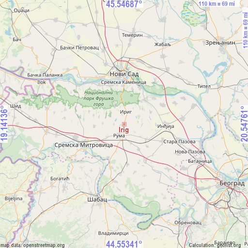
Irig GPS coordinates[2]
45° 3' 8.28" North, 19° 50' 40.128" East
| Map corner | latitude | longitude |
|---|---|---|
| Upper-left | 45.54687°, | 19.14136° |
| Center: | 45.0523°, | 19.84448° |
| Lower-right: | 44.55341°, | 20.54761° |
| Map W x H: | 110.5×110.5 km | = 68.7×68.7mi |
| max Lat: | 46.1° ⇑39.2% North |
| Irig: | 45.0523° |
| min Lat: | ⇓60.8% South 42.25846° |
| min Long | Irig | max Long |
| 18.9276° | 19.84448° | 22.77556° |
| W 28.3%⇐ | ⇒71.7% E |
Elevation
Elevation of Irig is 139 m = 456 ft, and this is 37.4 m = 123 ft below average elevation for this country.
| Max E: |
1421 m = 4662 ft | 32.4% |
| Avg. | 176.4 m = 579 ft | |
| Irig | 139 m = 456 ft | |
Min E: |
49 m = 161 ft | 67.6% |
See also: Serbia elevation on elevation.city.
Geographical zone
Irig is located in North temperate zone (between Tropic of Cancer and the Arctic Circle). Distance of this North polar circle is 2391.8 km =1486.2 mi to North.| Distance of | km | miles | from Irig |
|---|---|---|---|
| North Pole | 4997.7 | 3105.4 | to North |
| Arctic Circle | 2391.8 | 1486.2 | to North |
| Tropic Cancer | 2403.4 | 1493.4 | to South |
| Equator | 5009.3 | 3112.6 | to South |


Nearby cities:
15 places around Irig: (largest is in red/bold)
• Beočin
19.9 km =12.4 mi,  330°
330°
• Beška
19.5 km =12.1 mi,  63°
63°
• Buđanovci
17.7 km =11 mi,  175°
175°
• Golubinci
18.7 km =11.6 mi,  113°
113°
• Inđija
18.6 km =11.6 mi,  91°
91°
• Irig
5.5 km =3.4 mi,  11°
11°
• Jarak
16.5 km =10.3 mi,  205°
205°
• Ljukovo
14.7 km =9.1 mi,  101°
101°
• Pećinci
18.6 km =11.6 mi,  148°
148°
• Putinci
12 km =7.5 mi,  123°
123°
• Ruma
5.2 km =3.2 mi,  199°
199°
• Sremski Karlovci
18.1 km =11.2 mi,  22°
22°
• Vrdnik
8.7 km =5.4 mi, 332°
• Čortanovci
17.8 km =11.1 mi,  50°
50°
• Šašinci
12.6 km =7.8 mi,  219°
219°
Sources, notices
• [Note1] Compared only with cities in Serbia existing in our database
• [Src1] Map data: © OpenStreetMap contributors (CC-BY-SA)
• [Src2] Other city data from geonames.org with taken over terms of usage.
• [Src3] Geographical zone / Annual Mean Temperature by Robert A. Rohde @ Wikipedia
