Osečina geodata
Osečina (Central Serbia) is a seat of a third-order administrative division; located in Serbia in Europe/Belgrade (GMT+2) time zone. With population of 3,422 people, there are 130 cities with bigger population in this country. Compared to other cities in Serbia, 73.7% of cities are located further ↑North; 82.5% of cities are located further →East and 76.9% of cities have lower elevation than Osečina. Note1


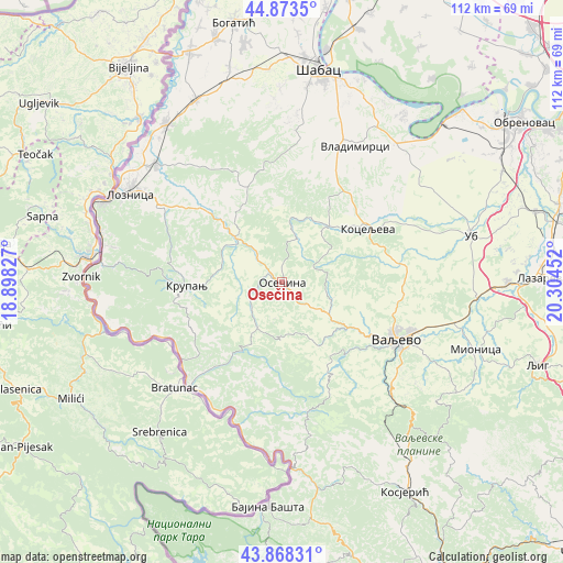
Osečina GPS coordinates[2]
44° 22' 23.016" North, 19° 36' 5.004" East
| Map corner | latitude | longitude |
|---|---|---|
| Upper-left | 44.8735°, | 18.89827° |
| Center: | 44.37306°, | 19.60139° |
| Lower-right: | 43.86831°, | 20.30452° |
| Map W x H: | 111.8×111.8 km | = 69.5×69.5mi |
| max Lat: | 46.1° ⇑73.7% North |
| Osečina: | 44.37306° |
| min Lat: | ⇓26.3% South 42.25846° |
| min Long | Osečina | max Long |
| 18.9276° | 19.60139° | 22.77556° |
| W 17.5%⇐ | ⇒82.5% E |
Elevation
Elevation of Osečina is 202 m = 663 ft, and this is 25.6 m = 84 ft above average elevation for this country.
| Max E: |
1421 m = 4662 ft | 23.1% |
| Osečina | 202 m 663 ft | |
| Avg. | 176.4 m = 579 ft | |
Min E: |
49 m = 161 ft | 76.9% |
See also: Serbia elevation on elevation.city.
Geographical zone
Osečina is located in North temperate zone (between Tropic of Cancer and the Arctic Circle). Distance of this Northern Tropic circle is 2327.9 km =1446.5 mi to South.| Distance of | km | miles | from Osečina |
|---|---|---|---|
| North Pole | 5073.2 | 3152.3 | to North |
| Arctic Circle | 2467.4 | 1533.2 | to North |
| Tropic Cancer | 2327.9 | 1446.5 | to South |
| Equator | 4933.8 | 3065.7 | to South |


Nearby cities:
15 places around Osečina: (largest is in red/bold)
• Belotić
24.9 km =15.5 mi,  22°
22°
• Brdarica
24.2 km =15 mi,  33°
33°
• Bukor
13.8 km =8.6 mi,  349°
349°
• Donja Badanja
17.8 km =11.1 mi,  325°
325°
• Draginje
21.9 km =13.6 mi,  35°
35°
• Gornja Bukovica
17.3 km =10.7 mi,  102°
102°
• Jarebice
23.3 km =14.5 mi,  322°
322°
• Kamenica
10.3 km =6.4 mi,  109°
109°
• Koceljeva
20.1 km =12.5 mi,  56°
56°
• Krivaja
19.7 km =12.2 mi,  357°
357°
• Krupanj
19.1 km =11.9 mi,  267°
267°
• Mrovska
19.8 km =12.3 mi, 17°
• Nakučani
25.9 km =16.1 mi,  11°
11°
• Rumska
22.2 km =13.8 mi, 357°
• Tekeriš
21.3 km =13.2 mi,  344°
344°
Sources, notices
• [Note1] Compared only with cities in Serbia existing in our database
• [Src1] Map data: © OpenStreetMap contributors (CC-BY-SA)
• [Src2] Other city data from geonames.org with taken over terms of usage.
• [Src3] Geographical zone / Annual Mean Temperature by Robert A. Rohde @ Wikipedia
