Koceljeva geodata
Koceljeva (Central Serbia) is a seat of a third-order administrative division; located in Serbia in Europe/Belgrade (GMT+2) time zone. In our database, there are 365 cities with bigger population. Compared to other cities in Serbia, 71.9% of cities are located further ↑North; 72.8% of cities are located further →East and 65.5% of cities have lower elevation than Koceljeva. Note1


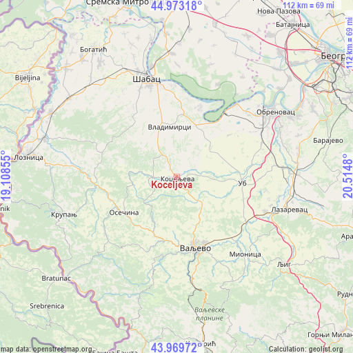
Koceljeva GPS coordinates[2]
44° 28' 24.996" North, 19° 48' 42.012" East
| Map corner | latitude | longitude |
|---|---|---|
| Upper-left | 44.97318°, | 19.10855° |
| Center: | 44.47361°, | 19.81167° |
| Lower-right: | 43.96972°, | 20.5148° |
| Map W x H: | 111.6×111.6 km | = 69.3×69.3mi |
| max Lat: | 46.1° ⇑71.9% North |
| Koceljeva: | 44.47361° |
| min Lat: | ⇓28.1% South 42.25846° |
| min Long | Koceljeva | max Long |
| 18.9276° | 19.81167° | 22.77556° |
| W 27.2%⇐ | ⇒72.8% E |
Elevation
Elevation of Koceljeva is 129 m = 423 ft, and this is 47.4 m = 156 ft below average elevation for this country.
| Max E: |
1421 m = 4662 ft | 34.5% |
| Avg. | 176.4 m = 579 ft | |
| Koceljeva | 129 m = 423 ft | |
Min E: |
49 m = 161 ft | 65.5% |
See also: Serbia elevation on elevation.city.
Geographical zone
Koceljeva is located in North temperate zone (between Tropic of Cancer and the Arctic Circle). Distance of this Northern Tropic circle is 2339.1 km =1453.4 mi to South.| Distance of | km | miles | from Koceljeva |
|---|---|---|---|
| North Pole | 5062.1 | 3145.4 | to North |
| Arctic Circle | 2456.2 | 1526.2 | to North |
| Tropic Cancer | 2339.1 | 1453.4 | to South |
| Equator | 4945 | 3072.7 | to South |


Nearby cities:
15 places around Koceljeva: (largest is in red/bold)
• Belotić
14 km =8.7 mi,  328°
328°
• Brdarica
9.5 km =5.9 mi,  340°
340°
• Bukor
19.2 km =11.9 mi,  277°
277°
• Draginje
7.7 km =4.8 mi, 329°
• Gornja Bukovica
14.9 km =9.3 mi,  179°
179°
• Kamenica
16.1 km =10 mi,  205°
205°
• Krivaja
19.4 km =12.1 mi,  296°
296°
• Mrovska
13.3 km =8.3 mi,  305°
305°
• Nakučani
18.2 km =11.3 mi,  321°
321°
• Osečina
20.1 km =12.5 mi,  236°
236°
• Rumska
20.7 km =12.9 mi, 302°
• Sinošević
21 km =13 mi, 318°
• Ub
20.9 km =13 mi,  95°
95°
• Valjevo
23.1 km =14.4 mi,  162°
162°
• Vladimirci
15.8 km =9.8 mi,  352°
352°
Sources, notices
• [Note1] Compared only with cities in Serbia existing in our database
• [Src1] Map data: © OpenStreetMap contributors (CC-BY-SA)
• [Src2] Other city data from geonames.org with taken over terms of usage.
• [Src3] Geographical zone / Annual Mean Temperature by Robert A. Rohde @ Wikipedia
