Bosut geodata
Bosut (Vojvodina) is a populated place; located in Serbia in Europe/Belgrade (GMT+2) time zone. With population of 1,311 people, there are 282 cities with bigger population in this country. Compared to other cities in Serbia, 54.4% of cities are located further ↓South; 93.4% of cities are located further →East and 71.9% of cities have higher elevation than Bosut. Note1


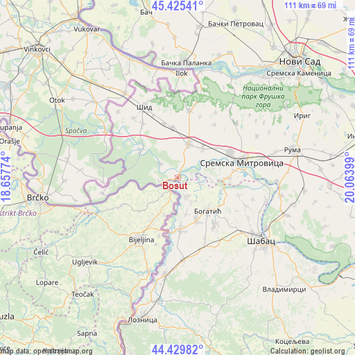
Bosut GPS coordinates[2]
44° 55' 47.172" North, 19° 21' 39.096" East
| Map corner | latitude | longitude |
|---|---|---|
| Upper-left | 45.42541°, | 18.65774° |
| Center: | 44.92977°, | 19.36086° |
| Lower-right: | 44.42982°, | 20.06399° |
| Map W x H: | 110.7×110.7 km | = 68.8×68.8mi |
| max Lat: | 46.1° ⇑45.6% North |
| Bosut: | 44.92977° |
| min Lat: | ⇓54.4% South 42.25846° |
| min Long | Bosut | max Long |
| 18.9276° | 19.36086° | 22.77556° |
| W 6.6%⇐ | ⇒93.4% E |
Elevation
Elevation of Bosut is 79 m = 259 ft, and this is 97.4 m = 320 ft below average elevation for this country.
| Max E: |
1421 m = 4662 ft | 71.9% |
| Avg. | 176.4 m = 579 ft | |
| Bosut | 79 m = 259 ft | |
Min E: |
49 m = 161 ft | 28.1% |
See also: Serbia elevation on elevation.city.
Geographical zone
Bosut is located in North temperate zone (between Tropic of Cancer and the Arctic Circle). Distance of this Northern Tropic circle is 2389.8 km =1485 mi to South.| Distance of | km | miles | from Bosut |
|---|---|---|---|
| North Pole | 5011.3 | 3113.9 | to North |
| Arctic Circle | 2405.5 | 1494.7 | to North |
| Tropic Cancer | 2389.8 | 1485 | to South |
| Equator | 4995.7 | 3104.2 | to South |


Nearby cities:
15 places around Bosut: (largest is in red/bold)
• Badovinci
16.1 km =10 mi,  177°
177°
• Banovo Polje
7.3 km =4.5 mi,  107°
107°
• Bogatić
13.9 km =8.6 mi,  137°
137°
• Crna Bara
6.8 km =4.2 mi,  156°
156°
• Glogovac
8.5 km =5.3 mi,  149°
149°
• Glušci
15.5 km =9.6 mi, 106°
• Klenje
14.8 km =9.2 mi, 156°
• Metković
16.8 km =10.4 mi,  119°
119°
• Radenković
10.6 km =6.6 mi,  94°
94°
• Ravnje
5.1 km =3.2 mi,  72°
72°
• Salaš Crnobarski
11.6 km =7.2 mi,  166°
166°
• Salaš Noćajski
17.8 km =11.1 mi,  83°
83°
• Sremska Rača
6 km =3.7 mi,  260°
260°
• Višnjićevo
7 km =4.3 mi,  306°
306°
• Zasavica Prva
10.5 km =6.5 mi, 74°
Sources, notices
• [Note1] Compared only with cities in Serbia existing in our database
• [Src1] Map data: © OpenStreetMap contributors (CC-BY-SA)
• [Src2] Other city data from geonames.org with taken over terms of usage.
• [Src3] Geographical zone / Annual Mean Temperature by Robert A. Rohde @ Wikipedia
