Kovačica geodata
Kovačica (Vojvodina) is a seat of a third-order administrative division; located in Serbia in Europe/Belgrade (GMT+2) time zone. With population of 7,357 people, there are 67 cities with bigger population in this country. Compared to other cities in Serbia, 63.7% of cities are located further ↓South; 64.2% of cities are located further ←West and 78.9% of cities have higher elevation than Kovačica. Note1


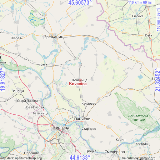
Kovačica GPS coordinates[2]
45° 6' 42.012" North, 20° 37' 17.004" East
| Map corner | latitude | longitude |
|---|---|---|
| Upper-left | 45.60573°, | 19.91827° |
| Center: | 45.11167°, | 20.62139° |
| Lower-right: | 44.6133°, | 21.32452° |
| Map W x H: | 110.3×110.3 km | = 68.5×68.5mi |
| max Lat: | 46.1° ⇑36.3% North |
| Kovačica: | 45.11167° |
| min Lat: | ⇓63.7% South 42.25846° |
| min Long | Kovačica | max Long |
| 18.9276° | 20.62139° | 22.77556° |
| W 64.2%⇐ | ⇒35.8% E |
Elevation
Elevation of Kovačica is 78 m = 256 ft, and this is 98.4 m = 323 ft below average elevation for this country.
| Max E: |
1421 m = 4662 ft | 78.9% |
| Avg. | 176.4 m = 579 ft | |
| Kovačica | 78 m = 256 ft | |
Min E: |
49 m = 161 ft | 21.1% |
See also: Serbia elevation on elevation.city.
Geographical zone
Kovačica is located in North temperate zone (between Tropic of Cancer and the Arctic Circle). Distance of this North polar circle is 2385.2 km =1482.1 mi to North.| Distance of | km | miles | from Kovačica |
|---|---|---|---|
| North Pole | 4991.1 | 3101.3 | to North |
| Arctic Circle | 2385.2 | 1482.1 | to North |
| Tropic Cancer | 2410 | 1497.5 | to South |
| Equator | 5015.9 | 3116.7 | to South |


Nearby cities:
15 places around Kovačica: (largest is in red/bold)
• Baranda
14.3 km =8.9 mi,  257°
257°
• Crepaja
11.4 km =7.1 mi,  173°
173°
• Debeljača
4.8 km =3 mi,  198°
198°
• Farkaždin
14.7 km =9.1 mi,  307°
307°
• Idvor
12 km =7.5 mi,  315°
315°
• Kozjak
20.6 km =12.8 mi,  67°
67°
• Opovo
16.4 km =10.2 mi,  246°
246°
• Orlovat
14.8 km =9.2 mi,  347°
347°
• Padina
8.5 km =5.3 mi,  83°
83°
• Sakule
11.3 km =7 mi,  290°
290°
• Samoš
15.7 km =9.8 mi,  49°
49°
• Sefkerin
16.1 km =10 mi,  222°
222°
• Tomaševac
17.4 km =10.8 mi,  0°
0°
• Uzdin
10.4 km =6.5 mi, 0°
• Čenta
18.2 km =11.3 mi,  268°
268°
Sources, notices
• [Note1] Compared only with cities in Serbia existing in our database
• [Src1] Map data: © OpenStreetMap contributors (CC-BY-SA)
• [Src2] Other city data from geonames.org with taken over terms of usage.
• [Src3] Geographical zone / Annual Mean Temperature by Robert A. Rohde @ Wikipedia
