Aleksandrovac geodata
Aleksandrovac (Central Serbia) is a seat of a third-order administrative division; located in Serbia in Europe/Belgrade (GMT+2) time zone. In our database, there are 365 cities with bigger population. Compared to other cities in Serbia, 87.1% of cities are located further ↑North; 75.7% of cities are located further ←West and 87.8% of cities have lower elevation than Aleksandrovac. Note1


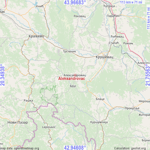
Aleksandrovac GPS coordinates[2]
43° 27' 30.996" North, 21° 3' 9" East
| Map corner | latitude | longitude |
|---|---|---|
| Upper-left | 43.96683°, | 20.34938° |
| Center: | 43.45861°, | 21.0525° |
| Lower-right: | 42.94608°, | 21.75563° |
| Map W x H: | 113.5×113.5 km | = 70.5×70.5mi |
| max Lat: | 46.1° ⇑87.1% North |
| Aleksandrovac: | 43.45861° |
| min Lat: | ⇓12.9% South 42.25846° |
| min Long | Aleksandrovac | max Long |
| 18.9276° | 21.0525° | 22.77556° |
| W 75.7%⇐ | ⇒24.3% E |
Elevation
Elevation of Aleksandrovac is 352 m = 1155 ft, and this is 175.6 m = 576 ft above average elevation for this country.
| Max E: |
1421 m = 4662 ft | 12.2% |
| Aleksandrovac | 352 m 1155 ft | |
| Avg. | 176.4 m = 579 ft | |
Min E: |
49 m = 161 ft | 87.8% |
See also: Serbia elevation on elevation.city.
Geographical zone
Aleksandrovac is located in North temperate zone (between Tropic of Cancer and the Arctic Circle). Distance of this Northern Tropic circle is 2226.2 km =1383.3 mi to South.| Distance of | km | miles | from Aleksandrovac |
|---|---|---|---|
| North Pole | 5174.9 | 3215.5 | to North |
| Arctic Circle | 2569 | 1596.3 | to North |
| Tropic Cancer | 2226.2 | 1383.3 | to South |
| Equator | 4832.1 | 3002.5 | to South |


Nearby cities:
15 places around Aleksandrovac: (largest is in red/bold)
• Bace
35.6 km =22.1 mi,  138°
138°
• Beloljin
37.1 km =23.1 mi,  131°
131°
• Blace
26.2 km =16.3 mi, 133°
• Donja Konjuša
39.3 km =24.4 mi, 131°
• Kraljevo
41.7 km =25.9 mi,  315°
315°
• Kruševac
26.4 km =16.4 mi,  59°
59°
• Kuršumlija
39.9 km =24.8 mi,  153°
153°
• Raška
40.1 km =24.9 mi,  241°
241°
• Rekovac
45.1 km =28 mi,  4°
4°
• Suvi Do
31.8 km =19.8 mi, 134°
• Trstenik
18.1 km =11.2 mi,  347°
347°
• Tulare
36.8 km =22.9 mi, 134°
• Varvarin
38.6 km =24 mi,  40°
40°
• Vrnjačka Banja
22.6 km =14 mi,  326°
326°
• Ćićevac
42.6 km =26.5 mi,  47°
47°
Sources, notices
• [Note1] Compared only with cities in Serbia existing in our database
• [Src1] Map data: © OpenStreetMap contributors (CC-BY-SA)
• [Src2] Other city data from geonames.org with taken over terms of usage.
• [Src3] Geographical zone / Annual Mean Temperature by Robert A. Rohde @ Wikipedia
