Ugrinovci geodata
Ugrinovci (Central Serbia) is a populated place; located in Serbia in Europe/Belgrade (GMT+2) time zone. With population of 3,278 people, there are 137 cities with bigger population in this country. Compared to other cities in Serbia, 51.7% of cities are located further ↓South; 58.7% of cities are located further →East and 94.6% of cities have higher elevation than Ugrinovci. Note1
Administrative division(s):
- Level 1: Central Serbia
- Level 2: Belgrade
- Level 3: Opština Beograd-Zemun


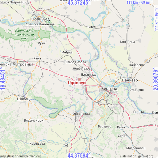
Ugrinovci GPS coordinates[2]
44° 52' 34.86" North, 20° 11' 15.468" East
| Map corner | latitude | longitude |
|---|---|---|
| Upper-left | 45.37245°, | 19.48451° |
| Center: | 44.87635°, | 20.18763° |
| Lower-right: | 44.37594°, | 20.89076° |
| Map W x H: | 110.8×110.8 km | = 68.8×68.8mi |
| max Lat: | 46.1° ⇑48.3% North |
| Ugrinovci: | 44.87635° |
| min Lat: | ⇓51.7% South 42.25846° |
| min Long | Ugrinovci | max Long |
| 18.9276° | 20.18763° | 22.77556° |
| W 41.3%⇐ | ⇒58.7% E |
Elevation
Elevation of Ugrinovci is 75 m = 246 ft, and this is 101.4 m = 333 ft below average elevation for this country.
| Max E: |
1421 m = 4662 ft | 94.6% |
| Avg. | 176.4 m = 579 ft | |
| Ugrinovci | 75 m = 246 ft | |
Min E: |
49 m = 161 ft | 5.4% |
See also: Serbia elevation on elevation.city.
Geographical zone
Ugrinovci is located in North temperate zone (between Tropic of Cancer and the Arctic Circle). Distance of this Northern Tropic circle is 2383.9 km =1481.3 mi to South.| Distance of | km | miles | from Ugrinovci |
|---|---|---|---|
| North Pole | 5017.3 | 3117.6 | to North |
| Arctic Circle | 2411.4 | 1498.4 | to North |
| Tropic Cancer | 2383.9 | 1481.3 | to South |
| Equator | 4989.8 | 3100.5 | to South |


Nearby cities:
15 places around Ugrinovci: (largest is in red/bold)
• Belegiš
19.6 km =12.2 mi,  35°
35°
• Bečmen
10.8 km =6.7 mi,  172°
172°
• Boljevci
17.2 km =10.7 mi, 170°
• Dobanovci
6.3 km =3.9 mi,  152°
152°
• Golubinci
15.6 km =9.7 mi,  321°
321°
• Nova Pazova
7.9 km =4.9 mi,  18°
18°
• Novi Banovci
11.6 km =7.2 mi, 39°
• Ostružnica
19.5 km =12.1 mi, 148°
• Pećinci
17.8 km =11.1 mi,  281°
281°
• Stara Pazova
12.3 km =7.6 mi,  350°
350°
• Stari Banovci
14.2 km =8.8 mi,  32°
32°
• Surčin
11.8 km =7.3 mi,  141°
141°
• Vojka
7.3 km =4.5 mi,  337°
337°
• Zemun
17.2 km =10.7 mi,  101°
101°
• Šimanovci
7.6 km =4.7 mi,  267°
267°
Sources, notices
• [Note1] Compared only with cities in Serbia existing in our database
• [Src1] Map data: © OpenStreetMap contributors (CC-BY-SA)
• [Src2] Other city data from geonames.org with taken over terms of usage.
• [Src3] Geographical zone / Annual Mean Temperature by Robert A. Rohde @ Wikipedia
