Lazarevac geodata
Lazarevac (Central Serbia) is a seat of a third-order administrative division; located in Serbia in Europe/Belgrade (GMT+2) time zone. With population of 23,551 people, there are 38 cities with bigger population in this country. Compared to other cities in Serbia, 73% of cities are located further ↑North; 55.8% of cities are located further →East and 62.6% of cities have lower elevation than Lazarevac. Note1
Administrative division(s):
- Level 1: Central Serbia
- Level 2: Belgrade
- Level 3: Opština Beograd-Lazarevac


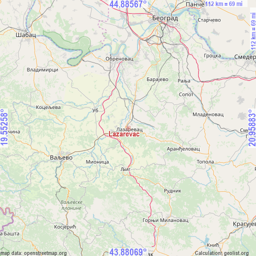
Lazarevac GPS coordinates[2]
44° 23' 7.224" North, 20° 15' 20.52" East
| Map corner | latitude | longitude |
|---|---|---|
| Upper-left | 44.88567°, | 19.55258° |
| Center: | 44.38534°, | 20.2557° |
| Lower-right: | 43.88069°, | 20.95883° |
| Map W x H: | 111.7×111.7 km | = 69.4×69.4mi |
| max Lat: | 46.1° ⇑73% North |
| Lazarevac: | 44.38534° |
| min Lat: | ⇓27% South 42.25846° |
| min Long | Lazarevac | max Long |
| 18.9276° | 20.2557° | 22.77556° |
| W 44.2%⇐ | ⇒55.8% E |
Elevation
Elevation of Lazarevac is 117 m = 384 ft, and this is 59.4 m = 195 ft below average elevation for this country.
| Max E: |
1421 m = 4662 ft | 37.4% |
| Avg. | 176.4 m = 579 ft | |
| Lazarevac | 117 m = 384 ft | |
Min E: |
49 m = 161 ft | 62.6% |
See also: Serbia elevation on elevation.city.
Geographical zone
Lazarevac is located in North temperate zone (between Tropic of Cancer and the Arctic Circle). Distance of this Northern Tropic circle is 2329.3 km =1447.4 mi to South.| Distance of | km | miles | from Lazarevac |
|---|---|---|---|
| North Pole | 5071.9 | 3151.5 | to North |
| Arctic Circle | 2466 | 1532.3 | to North |
| Tropic Cancer | 2329.3 | 1447.4 | to South |
| Equator | 4935.2 | 3066.6 | to South |


Nearby cities:
15 places around Lazarevac: (largest is in red/bold)
• Aranđelovac
25.7 km =16 mi,  109°
109°
• Barajevo
25 km =15.5 mi,  30°
30°
• Barič
29.5 km =18.3 mi,  0°
0°
• Grabovac
27.5 km =17.1 mi,  330°
330°
• Lajkovac
7.4 km =4.6 mi,  256°
256°
• Ljig
17.3 km =10.7 mi,  184°
184°
• Mala Moštanica
28.4 km =17.6 mi,  8°
8°
• Mionica
20.3 km =12.6 mi,  223°
223°
• Obrenovac
30.3 km =18.8 mi,  351°
351°
• Sopot
29.3 km =18.2 mi,  59°
59°
• Stepojevac
14.5 km =9 mi, 12°
• Stubline
23.1 km =14.4 mi,  335°
335°
• Ub
16.4 km =10.2 mi,  298°
298°
• Vranić
24.8 km =15.4 mi, 13°
• Zvečka
29.3 km =18.2 mi, 345°
Sources, notices
• [Note1] Compared only with cities in Serbia existing in our database
• [Src1] Map data: © OpenStreetMap contributors (CC-BY-SA)
• [Src2] Other city data from geonames.org with taken over terms of usage.
• [Src3] Geographical zone / Annual Mean Temperature by Robert A. Rohde @ Wikipedia
