Sopot geodata
Sopot (Central Serbia) is a seat of a third-order administrative division; located in Serbia in Europe/Belgrade (GMT+2) time zone. In our database, there are 365 cities with bigger population. Compared to other cities in Serbia, 70.1% of cities are located further ↑North; 62.4% of cities are located further ←West and 75.1% of cities have lower elevation than Sopot. Note1
Administrative division(s):
- Level 1: Central Serbia
- Level 2: Belgrade
- Level 3: Opština Beograd-Sopot


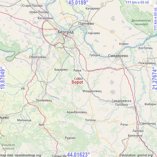
Sopot GPS coordinates[2]
44° 31' 10.992" North, 20° 34' 24.996" East
| Map corner | latitude | longitude |
|---|---|---|
| Upper-left | 45.0189°, | 19.87049° |
| Center: | 44.51972°, | 20.57361° |
| Lower-right: | 44.01623°, | 21.27674° |
| Map W x H: | 111.5×111.5 km | = 69.3×69.3mi |
| max Lat: | 46.1° ⇑70.1% North |
| Sopot: | 44.51972° |
| min Lat: | ⇓29.9% South 42.25846° |
| min Long | Sopot | max Long |
| 18.9276° | 20.57361° | 22.77556° |
| W 62.4%⇐ | ⇒37.6% E |
Elevation
Elevation of Sopot is 188 m = 617 ft, and this is 11.6 m = 38 ft above average elevation for this country.
| Max E: |
1421 m = 4662 ft | 24.9% |
| Sopot | 188 m 617 ft | |
| Avg. | 176.4 m = 579 ft | |
Min E: |
49 m = 161 ft | 75.1% |
See also: Serbia elevation on elevation.city.
Geographical zone
Sopot is located in North temperate zone (between Tropic of Cancer and the Arctic Circle). Distance of this Northern Tropic circle is 2344.2 km =1456.6 mi to South.| Distance of | km | miles | from Sopot |
|---|---|---|---|
| North Pole | 5056.9 | 3142.2 | to North |
| Arctic Circle | 2451 | 1523 | to North |
| Tropic Cancer | 2344.2 | 1456.6 | to South |
| Equator | 4950.1 | 3075.8 | to South |


Nearby cities:
15 places around Sopot: (largest is in red/bold)
• Aranđelovac
23.7 km =14.7 mi,  182°
182°
• Barajevo
14.1 km =8.8 mi,  297°
297°
• Barič
28.8 km =17.9 mi, 300°
• Grocka
20.3 km =12.6 mi,  33°
33°
• Lazarevac
29.3 km =18.2 mi,  239°
239°
• Mala Moštanica
25 km =15.5 mi, 301°
• Mladenovac
13.4 km =8.3 mi,  132°
132°
• Rakovica
26.8 km =16.7 mi,  337°
337°
• Rušanj
20.8 km =12.9 mi,  331°
331°
• Sremčica
22.6 km =14 mi,  320°
320°
• Stepojevac
22.1 km =13.7 mi,  267°
267°
• Umka
27.6 km =17.1 mi,  309°
309°
• Velika Moštanica
23.7 km =14.7 mi, 312°
• Vranić
21.5 km =13.4 mi, 295°
• Zvezdara
28.5 km =17.7 mi,  353°
353°
Sources, notices
• [Note1] Compared only with cities in Serbia existing in our database
• [Src1] Map data: © OpenStreetMap contributors (CC-BY-SA)
• [Src2] Other city data from geonames.org with taken over terms of usage.
• [Src3] Geographical zone / Annual Mean Temperature by Robert A. Rohde @ Wikipedia
