Soko Banja geodata
Soko Banja (Central Serbia) is a seat of a third-order administrative division; located in Serbia in Europe/Belgrade (GMT+2) time zone. In our database, there are 365 cities with bigger population. Compared to other cities in Serbia, 85% of cities are located further ↑North; 93.7% of cities are located further ←West and 85.3% of cities have lower elevation than Soko Banja. Note1


Soko Banja GPS coordinates[2]
43° 38' 35.988" North, 21° 52' 15.996" East
| Map corner | latitude | longitude |
|---|---|---|
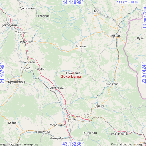
| Upper-left | 44.14999°, | 21.16799° |
| Center: | 43.64333°, | 21.87111° |
| Lower-right: | 43.13236°, | 22.57424° |
| Map W x H: | 113.1×113.1 km | = 70.3×70.3mi |
| max Lat: | 46.1° ⇑85% North |
| Soko Banja: | 43.64333° |
| min Lat: | ⇓15% South 42.25846° |
| min Long | Soko Banja | max Long |
| 18.9276° | 21.87111° | 22.77556° |
| W 93.7%⇐ | ⇒6.3% E |
Elevation
Elevation of Soko Banja is 310 m = 1017 ft, and this is 133.6 m = 438 ft above average elevation for this country.
| Max E: |
1421 m = 4662 ft | 14.7% |
| Soko Banja | 310 m 1017 ft | |
| Avg. | 176.4 m = 579 ft | |
Min E: |
49 m = 161 ft | 85.3% |
See also: Serbia elevation on elevation.city.
Geographical zone
Soko Banja is located in North temperate zone (between Tropic of Cancer and the Arctic Circle). Distance of this Northern Tropic circle is 2246.8 km =1396.1 mi to South.| Distance of | km | miles | from Soko Banja |
|---|---|---|---|
| North Pole | 5154.4 | 3202.8 | to North |
| Arctic Circle | 2548.5 | 1583.6 | to North |
| Tropic Cancer | 2246.8 | 1396.1 | to South |
| Equator | 4852.7 | 3015.3 | to South |


Nearby cities:
15 places around Soko Banja: (largest is in red/bold)
• Aleksinac
17.3 km =10.7 mi,  229°
229°
• Boljevac
21.8 km =13.5 mi,  17°
17°
• Dolac naselje
47.2 km =29.3 mi,  145°
145°
• Gadžin Han
48.5 km =30.1 mi,  164°
164°
• Knjazevac
32.2 km =20 mi,  105°
105°
• Kruševac
43.8 km =27.2 mi,  260°
260°
• Merošina
41.8 km =26 mi,  196°
196°
• Niš
35.5 km =22.1 mi,  175°
175°
• Niška Banja
40.2 km =25 mi, 164°
• Paraćin
44.4 km =27.6 mi,  303°
303°
• Ražanj
26.1 km =16.2 mi,  277°
277°
• Svrljig
32.6 km =20.3 mi,  141°
141°
• Varvarin
41.9 km =26 mi, 282°
• Zaječar
42.8 km =26.6 mi,  47°
47°
• Ćićevac
35.6 km =22.1 mi, 283°
Sources, notices
• [Note1] Compared only with cities in Serbia existing in our database
• [Src1] Map data: © OpenStreetMap contributors (CC-BY-SA)
• [Src2] Other city data from geonames.org with taken over terms of usage.
• [Src3] Geographical zone / Annual Mean Temperature by Robert A. Rohde @ Wikipedia
