Zaječar geodata
Zaječar (Central Serbia) is a seat of a second-order administrative division; located in Serbia in Europe/Belgrade (GMT+2) time zone. With population of 49,800 people, there are 18 cities with bigger population in this country. Compared to other cities in Serbia, 80.7% of cities are located further ↑North; 98.4% of cities are located further ←West and 66.2% of cities have lower elevation than Zaječar. Note1


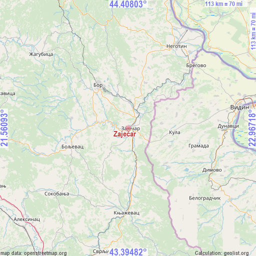
Zaječar GPS coordinates[2]
43° 54' 12.888" North, 22° 15' 50.58" East
| Map corner | latitude | longitude |
|---|---|---|
| Upper-left | 44.40803°, | 21.56093° |
| Center: | 43.90358°, | 22.26405° |
| Lower-right: | 43.39482°, | 22.96718° |
| Map W x H: | 112.7×112.7 km | = 70×70mi |
| max Lat: | 46.1° ⇑80.7% North |
| Zaječar: | 43.90358° |
| min Lat: | ⇓19.3% South 42.25846° |
| min Long | Zaječar | max Long |
| 18.9276° | 22.26405° | 22.77556° |
| W 98.4%⇐ | ⇒1.6% E |
Elevation
Elevation of Zaječar is 130 m = 427 ft, and this is 46.4 m = 152 ft below average elevation for this country.
| Max E: |
1421 m = 4662 ft | 33.8% |
| Avg. | 176.4 m = 579 ft | |
| Zaječar | 130 m = 427 ft | |
Min E: |
49 m = 161 ft | 66.2% |
See also: Zaječar elevation on elevation.city.
Geographical zone
Zaječar is located in North temperate zone (between Tropic of Cancer and the Arctic Circle). Distance of this Northern Tropic circle is 2275.7 km =1414.1 mi to South.| Distance of | km | miles | from Zaječar |
|---|---|---|---|
| North Pole | 5125.4 | 3184.8 | to North |
| Arctic Circle | 2519.6 | 1565.6 | to North |
| Tropic Cancer | 2275.7 | 1414.1 | to South |
| Equator | 4881.6 | 3033.3 | to South |


Nearby cities:
15 places around Zaječar: (largest is in red/bold)
• Aleksinac
60.1 km =37.3 mi,  228°
228°
• Boljevac
26.2 km =16.3 mi,  251°
251°
• Bor
23.3 km =14.5 mi,  324°
324°
• Despotovac
68.6 km =42.6 mi,  287°
287°
• Dolac naselje
67.8 km =42.1 mi,  183°
183°
• Donji Milanovac
63.2 km =39.3 mi,  351°
351°
• Knjazevac
37.5 km =23.3 mi, 180°
• Majdanpek
63.6 km =39.5 mi,  336°
336°
• Negotin
41.7 km =25.9 mi,  30°
30°
• Paraćin
68.8 km =42.8 mi,  266°
266°
• Ražanj
62.9 km =39.1 mi, 245°
• Soko Banja
42.8 km =26.6 mi, 227°
• Svrljig
55.7 km =34.6 mi,  191°
191°
• Ćićevac
69.2 km =43 mi, 252°
• Žagubica
50.1 km =31.1 mi,  310°
310°
Sources, notices
• [Note1] Compared only with cities in Serbia existing in our database
• [Src1] Map data: © OpenStreetMap contributors (CC-BY-SA)
• [Src2] Other city data from geonames.org with taken over terms of usage.
• [Src3] Geographical zone / Annual Mean Temperature by Robert A. Rohde @ Wikipedia
