Ćićevac geodata
Ćićevac (Central Serbia) is a seat of a third-order administrative division; located in Serbia in Europe/Belgrade (GMT+2) time zone. With population of 4 people, there are 359 cities with bigger population in this country. Compared to other cities in Serbia, 84.6% of cities are located further ↑North; 85.5% of cities are located further ←West and 68.7% of cities have lower elevation than Ćićevac. Note1


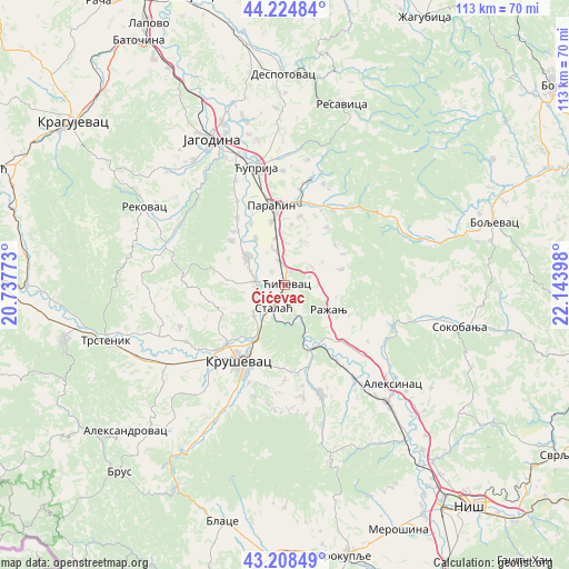
Ćićevac GPS coordinates[2]
43° 43' 7.752" North, 21° 26' 27.06" East
| Map corner | latitude | longitude |
|---|---|---|
| Upper-left | 44.22484°, | 20.73773° |
| Center: | 43.71882°, | 21.44085° |
| Lower-right: | 43.20849°, | 22.14398° |
| Map W x H: | 113×113 km | = 70.2×70.2mi |
| max Lat: | 46.1° ⇑84.6% North |
| Ćićevac: | 43.71882° |
| min Lat: | ⇓15.4% South 42.25846° |
| min Long | Ćićevac | max Long |
| 18.9276° | 21.44085° | 22.77556° |
| W 85.5%⇐ | ⇒14.5% E |
Elevation
Elevation of Ćićevac is 144 m = 472 ft, and this is 32.4 m = 106 ft below average elevation for this country.
| Max E: |
1421 m = 4662 ft | 31.3% |
| Avg. | 176.4 m = 579 ft | |
| Ćićevac | 144 m = 472 ft | |
Min E: |
49 m = 161 ft | 68.7% |
See also: Serbia elevation on elevation.city.
Geographical zone
Ćićevac is located in North temperate zone (between Tropic of Cancer and the Arctic Circle). Distance of this Northern Tropic circle is 2255.2 km =1401.3 mi to South.| Distance of | km | miles | from Ćićevac |
|---|---|---|---|
| North Pole | 5146 | 3197.6 | to North |
| Arctic Circle | 2540.1 | 1578.3 | to North |
| Tropic Cancer | 2255.2 | 1401.3 | to South |
| Equator | 4861.1 | 3020.5 | to South |


Nearby cities:
15 places around Ćićevac: (largest is in red/bold)
• Aleksandrovac
42.6 km =26.5 mi,  227°
227°
• Aleksinac
29.1 km =18.1 mi,  132°
132°
• Boljevac
43 km =26.7 mi,  73°
73°
• Despotovac
41.6 km =25.8 mi,  0°
0°
• Glogovac
37.4 km =23.2 mi,  344°
344°
• Jagodina
32.1 km =19.9 mi,  333°
333°
• Kruševac
17.7 km =11 mi,  209°
209°
• Paraćin
16 km =9.9 mi,  350°
350°
• Ražanj
10.2 km =6.3 mi,  120°
120°
• Rekovac
32.2 km =20 mi,  299°
299°
• Soko Banja
35.6 km =22.1 mi,  103°
103°
• Trstenik
37 km =23 mi,  252°
252°
• Varvarin
6.3 km =3.9 mi,  275°
275°
• Vrnjačka Banja
45 km =28 mi,  256°
256°
• Ćuprija
23.9 km =14.9 mi, 346°
Sources, notices
• [Note1] Compared only with cities in Serbia existing in our database
• [Src1] Map data: © OpenStreetMap contributors (CC-BY-SA)
• [Src2] Other city data from geonames.org with taken over terms of usage.
• [Src3] Geographical zone / Annual Mean Temperature by Robert A. Rohde @ Wikipedia
