Sanad geodata
Sanad (Vojvodina) is a populated place; located in Serbia in Europe/Belgrade (GMT+2) time zone. With population of 1,584 people, there are 250 cities with bigger population in this country. Compared to other cities in Serbia, 98.6% of cities are located further ↓South; 62.8% of cities are located further →East and 84.8% of cities have higher elevation than Sanad. Note1


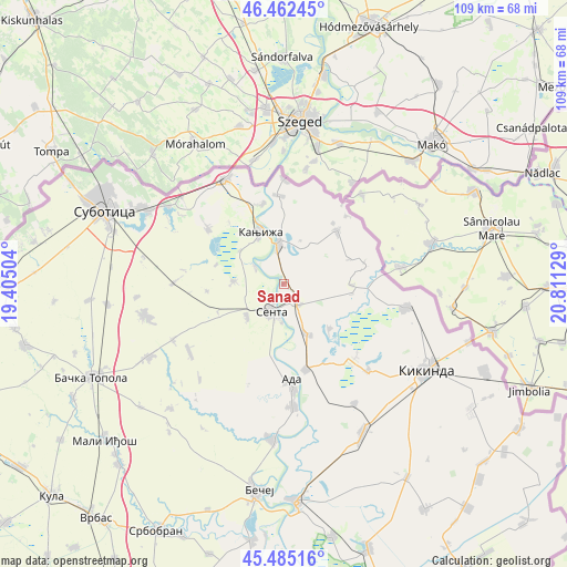
Sanad GPS coordinates[2]
45° 58' 33.456" North, 20° 6' 29.376" East
| Map corner | latitude | longitude |
|---|---|---|
| Upper-left | 46.46245°, | 19.40504° |
| Center: | 45.97596°, | 20.10816° |
| Lower-right: | 45.48516°, | 20.81129° |
| Map W x H: | 108.7×108.7 km | = 67.5×67.5mi |
| max Lat: | 46.1° ⇑1.4% North |
| Sanad: | 45.97596° |
| min Lat: | ⇓98.6% South 42.25846° |
| min Long | Sanad | max Long |
| 18.9276° | 20.10816° | 22.77556° |
| W 37.2%⇐ | ⇒62.8% E |
Elevation
Elevation of Sanad is 77 m = 253 ft, and this is 99.4 m = 326 ft below average elevation for this country.
| Max E: |
1421 m = 4662 ft | 84.8% |
| Avg. | 176.4 m = 579 ft | |
| Sanad | 77 m = 253 ft | |
Min E: |
49 m = 161 ft | 15.2% |
See also: Serbia elevation on elevation.city.
Geographical zone
Sanad is located in North temperate zone (between Tropic of Cancer and the Arctic Circle). Distance of this North polar circle is 2289.1 km =1422.4 mi to North.| Distance of | km | miles | from Sanad |
|---|---|---|---|
| North Pole | 4895 | 3041.6 | to North |
| Arctic Circle | 2289.1 | 1422.4 | to North |
| Tropic Cancer | 2506.1 | 1557.2 | to South |
| Equator | 5112 | 3176.4 | to South |


Nearby cities:
15 places around Sanad: (largest is in red/bold)
• Ada
19.3 km =12 mi,  175°
175°
• Adorjan
6.1 km =3.8 mi,  300°
300°
• Crna Bara
13 km =8.1 mi,  91°
91°
• Gornji Breg
9.4 km =5.8 mi,  228°
228°
• Jazovo
12.3 km =7.6 mi,  134°
134°
• Kanjiža
11 km =6.8 mi,  336°
336°
• Mol
23.6 km =14.7 mi, 175°
• Novi Kneževac
8.3 km =5.2 mi,  355°
355°
• Ostojićevo
10.7 km =6.6 mi,  155°
155°
• Padej
17 km =10.6 mi,  165°
165°
• Sajan
19.8 km =12.3 mi,  138°
138°
• Senta
5.9 km =3.7 mi,  203°
203°
• Tiszahegyes
23.2 km =14.4 mi, 135°
• Vrbica
16.2 km =10.1 mi,  78°
78°
• Čoka
4.6 km =2.9 mi, 143°
Sources, notices
• [Note1] Compared only with cities in Serbia existing in our database
• [Src1] Map data: © OpenStreetMap contributors (CC-BY-SA)
• [Src2] Other city data from geonames.org with taken over terms of usage.
• [Src3] Geographical zone / Annual Mean Temperature by Robert A. Rohde @ Wikipedia
