Ada geodata
Ada (Vojvodina) is a seat of a third-order administrative division; located in Serbia in Europe/Belgrade (GMT+2) time zone. In our database, there are 365 cities with bigger population. Compared to other cities in Serbia, 94.3% of cities are located further ↓South; 62.6% of cities are located further →East and 71.9% of cities have higher elevation than Ada. Note1


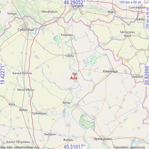
Ada GPS coordinates[2]
45° 48' 9" North, 20° 7' 32.988" East
| Map corner | latitude | longitude |
|---|---|---|
| Upper-left | 46.29052°, | 19.42271° |
| Center: | 45.8025°, | 20.12583° |
| Lower-right: | 45.31017°, | 20.82896° |
| Map W x H: | 109×109 km | = 67.7×67.7mi |
| max Lat: | 46.1° ⇑5.7% North |
| Ada: | 45.8025° |
| min Lat: | ⇓94.3% South 42.25846° |
| min Long | Ada | max Long |
| 18.9276° | 20.12583° | 22.77556° |
| W 37.4%⇐ | ⇒62.6% E |
Elevation
Elevation of Ada is 79 m = 259 ft, and this is 97.4 m = 320 ft below average elevation for this country.
| Max E: |
1421 m = 4662 ft | 71.9% |
| Avg. | 176.4 m = 579 ft | |
| Ada | 79 m = 259 ft | |
Min E: |
49 m = 161 ft | 28.1% |
See also: Serbia elevation on elevation.city.
Geographical zone
Ada is located in North temperate zone (between Tropic of Cancer and the Arctic Circle). Distance of this North polar circle is 2308.4 km =1434.4 mi to North.| Distance of | km | miles | from Ada |
|---|---|---|---|
| North Pole | 4914.3 | 3053.6 | to North |
| Arctic Circle | 2308.4 | 1434.4 | to North |
| Tropic Cancer | 2486.8 | 1545.2 | to South |
| Equator | 5092.8 | 3164.5 | to South |


Nearby cities:
15 places around Ada: (largest is in red/bold)
• Bačko Petrovo Selo
11.2 km =7 mi,  198°
198°
• Bečej
21.9 km =13.6 mi, 199°
• Bočar
12.8 km =8 mi,  106°
106°
• Crna Bara
22.3 km =13.9 mi,  31°
31°
• Gornji Breg
15.5 km =9.6 mi,  327°
327°
• Jazovo
13 km =8.1 mi, 34°
• Mol
4.3 km =2.7 mi,  172°
172°
• Novo Miloševo
16.6 km =10.3 mi,  123°
123°
• Ostojićevo
10.1 km =6.3 mi,  18°
18°
• Padej
4 km =2.5 mi,  45°
45°
• Sajan
12.6 km =7.8 mi,  69°
69°
• Sanad
19.3 km =12 mi,  355°
355°
• Senta
14.4 km =8.9 mi,  344°
344°
• Tiszahegyes
15.1 km =9.4 mi,  79°
79°
• Čoka
15.6 km =9.7 mi,  4°
4°
Sources, notices
• [Note1] Compared only with cities in Serbia existing in our database
• [Src1] Map data: © OpenStreetMap contributors (CC-BY-SA)
• [Src2] Other city data from geonames.org with taken over terms of usage.
• [Src3] Geographical zone / Annual Mean Temperature by Robert A. Rohde @ Wikipedia
