Novi Kneževac geodata
Novi Kneževac (Vojvodina) is a seat of a third-order administrative division; located in Serbia in Europe/Belgrade (GMT+2) time zone. With population of 8,166 people, there are 61 cities with bigger population in this country. Compared to other cities in Serbia, 99.5% of cities are located further ↓South; 63% of cities are located further →East and 90.7% of cities have higher elevation than Novi Kneževac. Note1


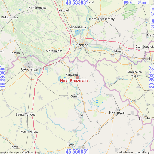
Novi Kneževac GPS coordinates[2]
46° 3' 0" North, 20° 6' 0" East
| Map corner | latitude | longitude |
|---|---|---|
| Upper-left | 46.53583°, | 19.39688° |
| Center: | 46.05°, | 20.1° |
| Lower-right: | 45.55985°, | 20.80313° |
| Map W x H: | 108.5×108.5 km | = 67.4×67.4mi |
| max Lat: | 46.1° ⇑0.5% North |
| Novi Kneževac: | 46.05° |
| min Lat: | ⇓99.5% South 42.25846° |
| min Long | Novi Kneževac | max Long |
| 18.9276° | 20.1° | 22.77556° |
| W 37%⇐ | ⇒63% E |
Elevation
Elevation of Novi Kneževac is 76 m = 249 ft, and this is 100.4 m = 329 ft below average elevation for this country.
| Max E: |
1421 m = 4662 ft | 90.7% |
| Avg. | 176.4 m = 579 ft | |
| Novi Kneževac | 76 m = 249 ft | |
Min E: |
49 m = 161 ft | 9.3% |
See also: Serbia elevation on elevation.city.
Geographical zone
Novi Kneževac is located in North temperate zone (between Tropic of Cancer and the Arctic Circle). Distance of this North polar circle is 2280.9 km =1417.3 mi to North.| Distance of | km | miles | from Novi Kneževac |
|---|---|---|---|
| North Pole | 4886.8 | 3036.5 | to North |
| Arctic Circle | 2280.9 | 1417.3 | to North |
| Tropic Cancer | 2514.4 | 1562.4 | to South |
| Equator | 5120.3 | 3181.6 | to South |


Nearby cities:
15 places around Novi Kneževac: (largest is in red/bold)
• Ada
27.6 km =17.1 mi,  175°
175°
• Adorjan
7 km =4.3 mi,  221°
221°
• Crna Bara
16.1 km =10 mi,  122°
122°
• Gornji Breg
15.8 km =9.8 mi,  203°
203°
• Jazovo
19.3 km =12 mi,  150°
150°
• Kanjiža
4.3 km =2.7 mi,  295°
295°
• Mokrin
27.4 km =17 mi, 118°
• Ostojićevo
18.7 km =11.6 mi,  164°
164°
• Padej
25.2 km =15.7 mi,  168°
168°
• Sajan
26.9 km =16.7 mi, 149°
• Sanad
8.3 km =5.2 mi, 175°
• Senta
13.7 km =8.5 mi,  187°
187°
• Tiszahegyes
30 km =18.6 mi, 145°
• Vrbica
17.2 km =10.7 mi,  106°
106°
• Čoka
12.4 km =7.7 mi, 164°
Sources, notices
• [Note1] Compared only with cities in Serbia existing in our database
• [Src1] Map data: © OpenStreetMap contributors (CC-BY-SA)
• [Src2] Other city data from geonames.org with taken over terms of usage.
• [Src3] Geographical zone / Annual Mean Temperature by Robert A. Rohde @ Wikipedia
