Elemir geodata
Elemir (Vojvodina) is a populated place; located in Serbia in Europe/Belgrade (GMT+2) time zone. With population of 4,998 people, there are 94 cities with bigger population in this country. Compared to other cities in Serbia, 82.5% of cities are located further ↓South; 53.3% of cities are located further →East and 63.3% of cities have higher elevation than Elemir. Note1


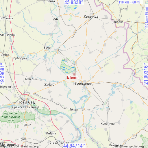
Elemir GPS coordinates[2]
45° 26' 33.468" North, 20° 18' 0.108" East
| Map corner | latitude | longitude |
|---|---|---|
| Upper-left | 45.9338°, | 19.59691° |
| Center: | 45.44263°, | 20.30003° |
| Lower-right: | 44.94714°, | 21.00316° |
| Map W x H: | 109.7×109.7 km | = 68.2×68.2mi |
| max Lat: | 46.1° ⇑17.5% North |
| Elemir: | 45.44263° |
| min Lat: | ⇓82.5% South 42.25846° |
| min Long | Elemir | max Long |
| 18.9276° | 20.30003° | 22.77556° |
| W 46.7%⇐ | ⇒53.3% E |
Elevation
Elevation of Elemir is 81 m = 266 ft, and this is 95.4 m = 313 ft below average elevation for this country.
| Max E: |
1421 m = 4662 ft | 63.3% |
| Avg. | 176.4 m = 579 ft | |
| Elemir | 81 m = 266 ft | |
Min E: |
49 m = 161 ft | 36.7% |
See also: Serbia elevation on elevation.city.
Geographical zone
Elemir is located in North temperate zone (between Tropic of Cancer and the Arctic Circle). Distance of this North polar circle is 2348.4 km =1459.2 mi to North.| Distance of | km | miles | from Elemir |
|---|---|---|---|
| North Pole | 4954.3 | 3078.5 | to North |
| Arctic Circle | 2348.4 | 1459.2 | to North |
| Tropic Cancer | 2446.8 | 1520.4 | to South |
| Equator | 5052.7 | 3139.6 | to South |


Nearby cities:
15 places around Elemir: (largest is in red/bold)
• Aradac
6.6 km =4.1 mi,  179°
179°
• Banatski Dvor
18.5 km =11.5 mi,  62°
62°
• Ečka
17.3 km =10.7 mi,  139°
139°
• Jankov Most
11.4 km =7.1 mi,  71°
71°
• Klek
14.3 km =8.9 mi,  99°
99°
• Kumane
12.1 km =7.5 mi,  332°
332°
• Lazarevo
19.7 km =12.2 mi,  107°
107°
• Lukino Selo
18.4 km =11.4 mi,  147°
147°
• Lukićevo
19.4 km =12.1 mi,  126°
126°
• Melenci
8.4 km =5.2 mi,  10°
10°
• Mihajlovo
9.5 km =5.9 mi, 70°
• Mošorin
18.7 km =11.6 mi,  213°
213°
• Taraš
8.4 km =5.2 mi,  289°
289°
• Zrenjanin
9.2 km =5.7 mi, 135°
• Čurug
18.3 km =11.4 mi,  280°
280°
Sources, notices
• [Note1] Compared only with cities in Serbia existing in our database
• [Src1] Map data: © OpenStreetMap contributors (CC-BY-SA)
• [Src2] Other city data from geonames.org with taken over terms of usage.
• [Src3] Geographical zone / Annual Mean Temperature by Robert A. Rohde @ Wikipedia
