Mokrin geodata
Mokrin (Vojvodina) is a populated place; located in Serbia in Europe/Belgrade (GMT+2) time zone. With population of 6,567 people, there are 71 cities with bigger population in this country. Compared to other cities in Serbia, 97.7% of cities are located further ↓South; 51.9% of cities are located further ←West and 84.8% of cities have higher elevation than Mokrin. Note1


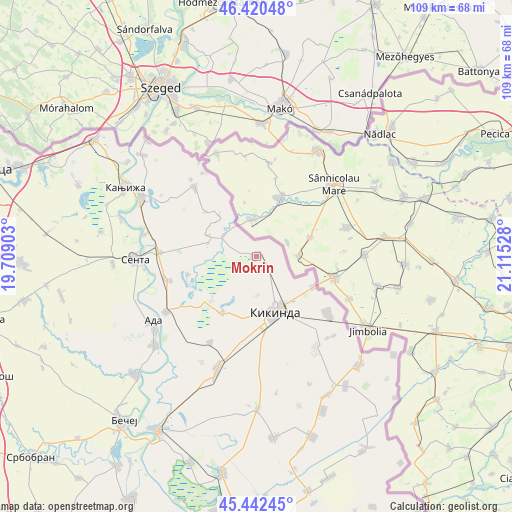
Mokrin GPS coordinates[2]
45° 56' 1.032" North, 20° 24' 43.74" East
| Map corner | latitude | longitude |
|---|---|---|
| Upper-left | 46.42048°, | 19.70903° |
| Center: | 45.93362°, | 20.41215° |
| Lower-right: | 45.44245°, | 21.11528° |
| Map W x H: | 108.7×108.7 km | = 67.5×67.5mi |
| max Lat: | 46.1° ⇑2.3% North |
| Mokrin: | 45.93362° |
| min Lat: | ⇓97.7% South 42.25846° |
| min Long | Mokrin | max Long |
| 18.9276° | 20.41215° | 22.77556° |
| W 51.9%⇐ | ⇒48.1% E |
Elevation
Elevation of Mokrin is 77 m = 253 ft, and this is 99.4 m = 326 ft below average elevation for this country.
| Max E: |
1421 m = 4662 ft | 84.8% |
| Avg. | 176.4 m = 579 ft | |
| Mokrin | 77 m = 253 ft | |
Min E: |
49 m = 161 ft | 15.2% |
See also: Serbia elevation on elevation.city.
Geographical zone
Mokrin is located in North temperate zone (between Tropic of Cancer and the Arctic Circle). Distance of this North polar circle is 2293.8 km =1425.3 mi to North.| Distance of | km | miles | from Mokrin |
|---|---|---|---|
| North Pole | 4899.7 | 3044.5 | to North |
| Arctic Circle | 2293.8 | 1425.3 | to North |
| Tropic Cancer | 2501.4 | 1554.3 | to South |
| Equator | 5107.3 | 3173.5 | to South |


Nearby cities:
15 places around Mokrin: (largest is in red/bold)
• Banatsko Veliko Selo
19.7 km =12.2 mi,  129°
129°
• Bočar
20.7 km =12.9 mi,  208°
208°
• Crna Bara
11.4 km =7.1 mi,  292°
292°
• Jazovo
15.3 km =9.5 mi,  255°
255°
• Kikinda
12.3 km =7.6 mi,  160°
160°
• Nakovo
13.6 km =8.5 mi,  118°
118°
• Novi Kozarci
23.4 km =14.5 mi,  135°
135°
• Ostojićevo
19.7 km =12.2 mi, 255°
• Padej
22.6 km =14 mi,  238°
238°
• Rusko Selo
22.6 km =14 mi,  147°
147°
• Sajan
14.5 km =9 mi,  225°
225°
• Sanad
24 km =14.9 mi,  281°
281°
• Tiszahegyes
14 km =8.7 mi, 211°
• Vrbica
11.1 km =6.9 mi,  316°
316°
• Čoka
20.8 km =12.9 mi,  272°
272°
Sources, notices
• [Note1] Compared only with cities in Serbia existing in our database
• [Src1] Map data: © OpenStreetMap contributors (CC-BY-SA)
• [Src2] Other city data from geonames.org with taken over terms of usage.
• [Src3] Geographical zone / Annual Mean Temperature by Robert A. Rohde @ Wikipedia
