Kikinda geodata
Kikinda (Vojvodina) is a seat of a second-order administrative division; located in Serbia in Europe/Belgrade (GMT+2) time zone. With population of 41,935 people, there are 21 cities with bigger population in this country. Compared to other cities in Serbia, 95.5% of cities are located further ↓South; 56.7% of cities are located further ←West and 56.5% of cities have higher elevation than Kikinda. Note1


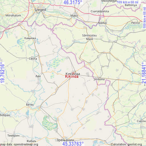
Kikinda GPS coordinates[2]
45° 49' 46.992" North, 20° 27' 55.008" East
| Map corner | latitude | longitude |
|---|---|---|
| Upper-left | 46.3175°, | 19.76216° |
| Center: | 45.82972°, | 20.46528° |
| Lower-right: | 45.33763°, | 21.16841° |
| Map W x H: | 109×108.9 km | = 67.7×67.7mi |
| max Lat: | 46.1° ⇑4.5% North |
| Kikinda: | 45.82972° |
| min Lat: | ⇓95.5% South 42.25846° |
| min Long | Kikinda | max Long |
| 18.9276° | 20.46528° | 22.77556° |
| W 56.7%⇐ | ⇒43.3% E |
Elevation
Elevation of Kikinda is 84 m = 276 ft, and this is 92.4 m = 303 ft below average elevation for this country.
| Max E: |
1421 m = 4662 ft | 56.5% |
| Avg. | 176.4 m = 579 ft | |
| Kikinda | 84 m = 276 ft | |
Min E: |
49 m = 161 ft | 43.5% |
See also: Kikinda elevation on elevation.city.
Geographical zone
Kikinda is located in North temperate zone (between Tropic of Cancer and the Arctic Circle). Distance of this North polar circle is 2305.4 km =1432.5 mi to North.| Distance of | km | miles | from Kikinda |
|---|---|---|---|
| North Pole | 4911.3 | 3051.7 | to North |
| Arctic Circle | 2305.4 | 1432.5 | to North |
| Tropic Cancer | 2489.9 | 1547.2 | to South |
| Equator | 5095.8 | 3166.4 | to South |


Nearby cities:
15 places around Kikinda: (largest is in red/bold)
• Banatska Topola
17.5 km =10.9 mi,  179°
179°
• Banatsko Veliko Selo
11.1 km =6.9 mi,  95°
95°
• Bašaid
21.4 km =13.3 mi,  190°
190°
• Bočar
15.6 km =9.7 mi,  244°
244°
• Jazovo
20.4 km =12.7 mi,  292°
292°
• Mokrin
12.3 km =7.6 mi,  340°
340°
• Nakovo
9.4 km =5.8 mi,  57°
57°
• Nova Crnja
21 km =13 mi,  148°
148°
• Novi Kozarci
13.3 km =8.3 mi,  113°
113°
• Novo Miloševo
17.6 km =10.9 mi,  225°
225°
• Rusko Selo
11.1 km =6.9 mi,  132°
132°
• Sajan
14.6 km =9.1 mi,  275°
275°
• Srpska Crnja
20.9 km =13 mi,  123°
123°
• Tiszahegyes
11.4 km =7.1 mi,  268°
268°
• Toba
17.1 km =10.6 mi,  155°
155°
Sources, notices
• [Note1] Compared only with cities in Serbia existing in our database
• [Src1] Map data: © OpenStreetMap contributors (CC-BY-SA)
• [Src2] Other city data from geonames.org with taken over terms of usage.
• [Src3] Geographical zone / Annual Mean Temperature by Robert A. Rohde @ Wikipedia
