Baranda geodata
Baranda (Vojvodina) is a populated place; located in Serbia in Europe/Belgrade (GMT+2) time zone. With population of 1,656 people, there are 244 cities with bigger population in this country. Compared to other cities in Serbia, 62.8% of cities are located further ↓South; 54.6% of cities are located further ←West and 94.6% of cities have higher elevation than Baranda. Note1


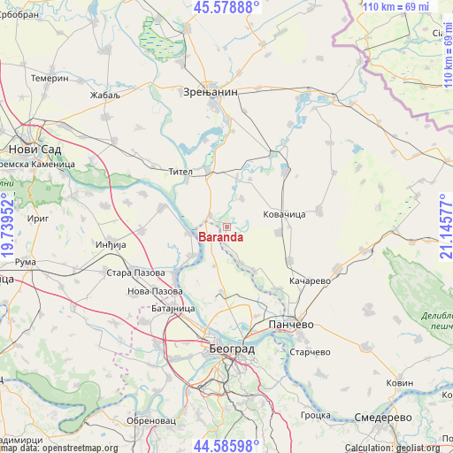
Baranda GPS coordinates[2]
45° 5' 4.524" North, 20° 26' 33.504" East
| Map corner | latitude | longitude |
|---|---|---|
| Upper-left | 45.57888°, | 19.73952° |
| Center: | 45.08459°, | 20.44264° |
| Lower-right: | 44.58598°, | 21.14577° |
| Map W x H: | 110.4×110.4 km | = 68.6×68.6mi |
| max Lat: | 46.1° ⇑37.2% North |
| Baranda: | 45.08459° |
| min Lat: | ⇓62.8% South 42.25846° |
| min Long | Baranda | max Long |
| 18.9276° | 20.44264° | 22.77556° |
| W 54.6%⇐ | ⇒45.4% E |
Elevation
Elevation of Baranda is 75 m = 246 ft, and this is 101.4 m = 333 ft below average elevation for this country.
| Max E: |
1421 m = 4662 ft | 94.6% |
| Avg. | 176.4 m = 579 ft | |
| Baranda | 75 m = 246 ft | |
Min E: |
49 m = 161 ft | 5.4% |
See also: Serbia elevation on elevation.city.
Geographical zone
Baranda is located in North temperate zone (between Tropic of Cancer and the Arctic Circle). Distance of this North polar circle is 2388.2 km =1484 mi to North.| Distance of | km | miles | from Baranda |
|---|---|---|---|
| North Pole | 4994.1 | 3103.2 | to North |
| Arctic Circle | 2388.2 | 1484 | to North |
| Tropic Cancer | 2407 | 1495.6 | to South |
| Equator | 5012.9 | 3114.9 | to South |


Nearby cities:
15 places around Baranda: (largest is in red/bold)
• Belegiš
11.3 km =7 mi,  229°
229°
• Debeljača
12.6 km =7.8 mi,  97°
97°
• Farkaždin
12.1 km =7.5 mi,  11°
11°
• Idvor
12.9 km =8 mi,  25°
25°
• Knićanin
14.9 km =9.3 mi,  319°
319°
• Kovačica
14.3 km =8.9 mi,  77°
77°
• Novi Slankamen
16.6 km =10.3 mi,  285°
285°
• Opovo
3.7 km =2.3 mi,  195°
195°
• Perlez
14.5 km =9 mi,  340°
340°
• Sakule
7.7 km =4.8 mi, 26°
• Sefkerin
9.4 km =5.8 mi,  160°
160°
• Stari Banovci
16.7 km =10.4 mi, 228°
• Stari Slankamen
15.9 km =9.9 mi, 293°
• Surduk
9.3 km =5.8 mi,  260°
260°
• Čenta
4.9 km =3 mi,  302°
302°
Sources, notices
• [Note1] Compared only with cities in Serbia existing in our database
• [Src1] Map data: © OpenStreetMap contributors (CC-BY-SA)
• [Src2] Other city data from geonames.org with taken over terms of usage.
• [Src3] Geographical zone / Annual Mean Temperature by Robert A. Rohde @ Wikipedia
