Glogovac geodata
Glogovac (Central Serbia) is a populated place; located in Serbia in Europe/Belgrade (GMT+2) time zone. With population of 1,000 people, there are 316 cities with bigger population in this country. Compared to other cities in Serbia, 78.7% of cities are located further ↑North; 81.6% of cities are located further ←West and 62.8% of cities have lower elevation than Glogovac. Note1


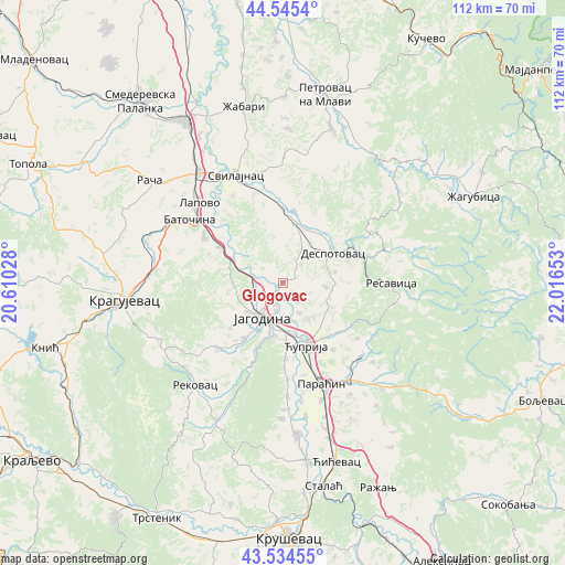
Glogovac GPS coordinates[2]
44° 2' 31.668" North, 21° 18' 48.24" East
| Map corner | latitude | longitude |
|---|---|---|
| Upper-left | 44.5454°, | 20.61028° |
| Center: | 44.04213°, | 21.3134° |
| Lower-right: | 43.53455°, | 22.01653° |
| Map W x H: | 112.4×112.4 km | = 69.8×69.8mi |
| max Lat: | 46.1° ⇑78.7% North |
| Glogovac: | 44.04213° |
| min Lat: | ⇓21.3% South 42.25846° |
| min Long | Glogovac | max Long |
| 18.9276° | 21.3134° | 22.77556° |
| W 81.6%⇐ | ⇒18.4% E |
Elevation
Elevation of Glogovac is 118 m = 387 ft, and this is 58.4 m = 192 ft below average elevation for this country.
| Max E: |
1421 m = 4662 ft | 37.2% |
| Avg. | 176.4 m = 579 ft | |
| Glogovac | 118 m = 387 ft | |
Min E: |
49 m = 161 ft | 62.8% |
See also: Serbia elevation on elevation.city.
Geographical zone
Glogovac is located in North temperate zone (between Tropic of Cancer and the Arctic Circle). Distance of this Northern Tropic circle is 2291.1 km =1423.6 mi to South.| Distance of | km | miles | from Glogovac |
|---|---|---|---|
| North Pole | 5110 | 3175.2 | to North |
| Arctic Circle | 2504.1 | 1556 | to North |
| Tropic Cancer | 2291.1 | 1423.6 | to South |
| Equator | 4897 | 3042.9 | to South |


Nearby cities:
15 places around Glogovac: (largest is in red/bold)
• Batočina
22.3 km =13.9 mi,  303°
303°
• Despotovac
12 km =7.5 mi,  62°
62°
• Jagodina
8.3 km =5.2 mi,  210°
210°
• Kragujevac
31.8 km =19.8 mi,  264°
264°
• Lapovo
23.4 km =14.5 mi,  312°
312°
• Paraćin
21.5 km =13.4 mi,  159°
159°
• Petrovac
38.2 km =23.7 mi,  12°
12°
• Rača
33.8 km =21 mi, 307°
• Rekovac
26.6 km =16.5 mi,  221°
221°
• Svilajnac
23.2 km =14.4 mi,  336°
336°
• Varvarin
35.6 km =22.1 mi,  173°
173°
• Velika Plana
37.5 km =23.3 mi,  329°
329°
• Ćićevac
37.4 km =23.2 mi, 164°
• Ćuprija
13.5 km =8.4 mi, 160°
• Žabari
35.8 km =22.2 mi,  347°
347°
Sources, notices
• [Note1] Compared only with cities in Serbia existing in our database
• [Src1] Map data: © OpenStreetMap contributors (CC-BY-SA)
• [Src2] Other city data from geonames.org with taken over terms of usage.
• [Src3] Geographical zone / Annual Mean Temperature by Robert A. Rohde @ Wikipedia
