Ćuprija geodata
Ćuprija (Central Serbia) is a seat of a third-order administrative division; located in Serbia in Europe/Belgrade (GMT+2) time zone. With population of 20,585 people, there are 40 cities with bigger population in this country. Compared to other cities in Serbia, 80.3% of cities are located further ↑North; 83.2% of cities are located further ←West and 64.9% of cities have lower elevation than Ćuprija. Note1


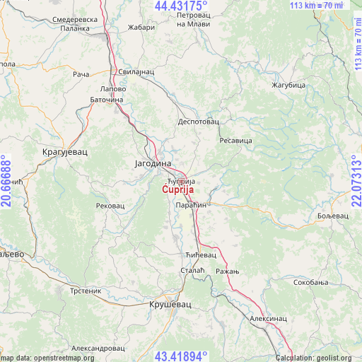
Ćuprija GPS coordinates[2]
43° 55' 39" North, 21° 22' 12" East
| Map corner | latitude | longitude |
|---|---|---|
| Upper-left | 44.43175°, | 20.66688° |
| Center: | 43.9275°, | 21.37° |
| Lower-right: | 43.41894°, | 22.07313° |
| Map W x H: | 112.6×112.6 km | = 70×70mi |
| max Lat: | 46.1° ⇑80.3% North |
| Ćuprija: | 43.9275° |
| min Lat: | ⇓19.7% South 42.25846° |
| min Long | Ćuprija | max Long |
| 18.9276° | 21.37° | 22.77556° |
| W 83.2%⇐ | ⇒16.8% E |
Elevation
Elevation of Ćuprija is 124 m = 407 ft, and this is 52.4 m = 172 ft below average elevation for this country.
| Max E: |
1421 m = 4662 ft | 35.1% |
| Avg. | 176.4 m = 579 ft | |
| Ćuprija | 124 m = 407 ft | |
Min E: |
49 m = 161 ft | 64.9% |
See also: Serbia elevation on elevation.city.
Geographical zone
Ćuprija is located in North temperate zone (between Tropic of Cancer and the Arctic Circle). Distance of this Northern Tropic circle is 2278.4 km =1415.7 mi to South.| Distance of | km | miles | from Ćuprija |
|---|---|---|---|
| North Pole | 5122.8 | 3183.2 | to North |
| Arctic Circle | 2516.9 | 1563.9 | to North |
| Tropic Cancer | 2278.4 | 1415.7 | to South |
| Equator | 4884.3 | 3035 | to South |


Nearby cities:
15 places around Ćuprija: (largest is in red/bold)
• Batočina
34.1 km =21.2 mi,  317°
317°
• Despotovac
19.4 km =12.1 mi,  18°
18°
• Glogovac
13.5 km =8.4 mi,  340°
340°
• Jagodina
10.3 km =6.4 mi,  302°
302°
• Kragujevac
37.6 km =23.4 mi,  285°
285°
• Kruševac
38.7 km =24 mi,  184°
184°
• Lapovo
35.9 km =22.3 mi, 322°
• Paraćin
8 km =5 mi,  157°
157°
• Ražanj
31.8 km =19.8 mi,  153°
153°
• Rekovac
23.3 km =14.5 mi,  252°
252°
• Svilajnac
36.8 km =22.9 mi, 337°
• Trstenik
45.4 km =28.2 mi,  220°
220°
• Varvarin
22.6 km =14 mi, 181°
• Ćićevac
23.9 km =14.9 mi,  166°
166°
• Žagubica
44.9 km =27.9 mi,  48°
48°
Sources, notices
• [Note1] Compared only with cities in Serbia existing in our database
• [Src1] Map data: © OpenStreetMap contributors (CC-BY-SA)
• [Src2] Other city data from geonames.org with taken over terms of usage.
• [Src3] Geographical zone / Annual Mean Temperature by Robert A. Rohde @ Wikipedia
