Bašaid geodata
Bašaid (Vojvodina) is a populated place; located in Serbia in Europe/Belgrade (GMT+2) time zone. With population of 3,864 people, there are 115 cities with bigger population in this country. Compared to other cities in Serbia, 90% of cities are located further ↓South; 52.2% of cities are located further ←West and 71.9% of cities have higher elevation than Bašaid. Note1


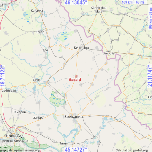
Bašaid GPS coordinates[2]
45° 38' 27.672" North, 20° 24' 51.624" East
| Map corner | latitude | longitude |
|---|---|---|
| Upper-left | 46.13045°, | 19.71122° |
| Center: | 45.64102°, | 20.41434° |
| Lower-right: | 45.14727°, | 21.11747° |
| Map W x H: | 109.3×109.3 km | = 67.9×67.9mi |
| max Lat: | 46.1° ⇑10% North |
| Bašaid: | 45.64102° |
| min Lat: | ⇓90% South 42.25846° |
| min Long | Bašaid | max Long |
| 18.9276° | 20.41434° | 22.77556° |
| W 52.2%⇐ | ⇒47.8% E |
Elevation
Elevation of Bašaid is 79 m = 259 ft, and this is 97.4 m = 320 ft below average elevation for this country.
| Max E: |
1421 m = 4662 ft | 71.9% |
| Avg. | 176.4 m = 579 ft | |
| Bašaid | 79 m = 259 ft | |
Min E: |
49 m = 161 ft | 28.1% |
See also: Serbia elevation on elevation.city.
Geographical zone
Bašaid is located in North temperate zone (between Tropic of Cancer and the Arctic Circle). Distance of this North polar circle is 2326.4 km =1445.6 mi to North.| Distance of | km | miles | from Bašaid |
|---|---|---|---|
| North Pole | 4932.3 | 3064.8 | to North |
| Arctic Circle | 2326.4 | 1445.6 | to North |
| Tropic Cancer | 2468.9 | 1534.1 | to South |
| Equator | 5074.8 | 3153.3 | to South |


Nearby cities:
15 places around Bašaid: (largest is in red/bold)
• Aleksandrovo
13.9 km =8.6 mi,  91°
91°
• Banatska Topola
5.3 km =3.3 mi,  48°
48°
• Banatski Dvor
15.6 km =9.7 mi,  150°
150°
• Banatsko Karađorđevo
13.1 km =8.1 mi,  117°
117°
• Bočar
17.6 km =10.9 mi,  324°
324°
• Jankov Most
18.6 km =11.6 mi,  174°
174°
• Kumane
18.3 km =11.4 mi,  231°
231°
• Melenci
15.7 km =9.8 mi,  208°
208°
• Mihajlovo
18.9 km =11.7 mi,  179°
179°
• Nova Crnja
15.1 km =9.4 mi,  78°
78°
• Novo Miloševo
12.2 km =7.6 mi, 315°
• Rusko Selo
18.2 km =11.3 mi,  41°
41°
• Toba
12.3 km =7.6 mi,  64°
64°
• Torda
7.2 km =4.5 mi, 151°
• Čestereg
12.6 km =7.8 mi,  133°
133°
Sources, notices
• [Note1] Compared only with cities in Serbia existing in our database
• [Src1] Map data: © OpenStreetMap contributors (CC-BY-SA)
• [Src2] Other city data from geonames.org with taken over terms of usage.
• [Src3] Geographical zone / Annual Mean Temperature by Robert A. Rohde @ Wikipedia
