Kumane geodata
Kumane (Vojvodina) is a populated place; located in Serbia in Europe/Belgrade (GMT+2) time zone. With population of 4,321 people, there are 105 cities with bigger population in this country. Compared to other cities in Serbia, 86.8% of cities are located further ↓South; 56.7% of cities are located further →East and 84.8% of cities have higher elevation than Kumane. Note1


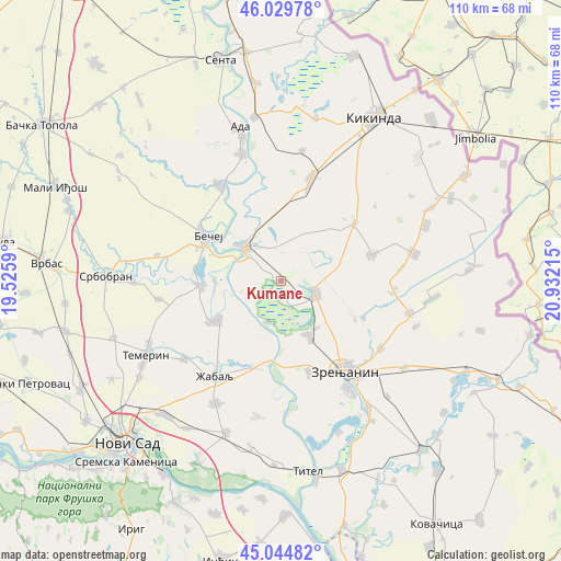
Kumane GPS coordinates[2]
45° 32' 22.056" North, 20° 13' 44.472" East
| Map corner | latitude | longitude |
|---|---|---|
| Upper-left | 46.02978°, | 19.5259° |
| Center: | 45.53946°, | 20.22902° |
| Lower-right: | 45.04482°, | 20.93215° |
| Map W x H: | 109.5×109.5 km | = 68×68mi |
| max Lat: | 46.1° ⇑13.2% North |
| Kumane: | 45.53946° |
| min Lat: | ⇓86.8% South 42.25846° |
| min Long | Kumane | max Long |
| 18.9276° | 20.22902° | 22.77556° |
| W 43.3%⇐ | ⇒56.7% E |
Elevation
Elevation of Kumane is 77 m = 253 ft, and this is 99.4 m = 326 ft below average elevation for this country.
| Max E: |
1421 m = 4662 ft | 84.8% |
| Avg. | 176.4 m = 579 ft | |
| Kumane | 77 m = 253 ft | |
Min E: |
49 m = 161 ft | 15.2% |
See also: Serbia elevation on elevation.city.
Geographical zone
Kumane is located in North temperate zone (between Tropic of Cancer and the Arctic Circle). Distance of this North polar circle is 2337.7 km =1452.6 mi to North.| Distance of | km | miles | from Kumane |
|---|---|---|---|
| North Pole | 4943.5 | 3071.7 | to North |
| Arctic Circle | 2337.7 | 1452.6 | to North |
| Tropic Cancer | 2457.6 | 1527.1 | to South |
| Equator | 5063.5 | 3146.3 | to South |


Nearby cities:
15 places around Kumane: (largest is in red/bold)
• Aradac
18.2 km =11.3 mi,  161°
161°
• Bačko Gradište
15.5 km =9.6 mi,  267°
267°
• Bačko Petrovo Selo
22 km =13.7 mi,  327°
327°
• Bašaid
18.3 km =11.4 mi,  51°
51°
• Bečej
17.5 km =10.9 mi,  299°
299°
• Elemir
12.1 km =7.5 mi,  152°
152°
• Jankov Most
17.8 km =11.1 mi,  113°
113°
• Melenci
7.5 km =4.7 mi, 109°
• Mihajlovo
16.4 km =10.2 mi,  117°
117°
• Novi Bečej
9.8 km =6.1 mi,  312°
312°
• Novo Miloševo
20.8 km =12.9 mi,  16°
16°
• Taraš
8.4 km =5.2 mi,  196°
196°
• Torda
18.6 km =11.6 mi,  74°
74°
• Zrenjanin
21 km =13 mi, 145°
• Čurug
14.6 km =9.1 mi,  239°
239°
Sources, notices
• [Note1] Compared only with cities in Serbia existing in our database
• [Src1] Map data: © OpenStreetMap contributors (CC-BY-SA)
• [Src2] Other city data from geonames.org with taken over terms of usage.
• [Src3] Geographical zone / Annual Mean Temperature by Robert A. Rohde @ Wikipedia
