Raška geodata
Raška (Central Serbia) is a seat of a third-order administrative division; located in Serbia in Europe/Belgrade (GMT+2) time zone. With population of 4 people, there are 359 cities with bigger population in this country. Compared to other cities in Serbia, 88.7% of cities are located further ↑North; 63.9% of cities are located further ←West and 90.9% of cities have lower elevation than Raška. Note1


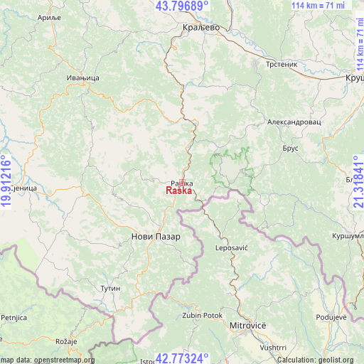
Raška GPS coordinates[2]
43° 17' 13.992" North, 20° 36' 55.008" East
| Map corner | latitude | longitude |
|---|---|---|
| Upper-left | 43.79689°, | 19.91216° |
| Center: | 43.28722°, | 20.61528° |
| Lower-right: | 42.77324°, | 21.31841° |
| Map W x H: | 113.8×113.8 km | = 70.7×70.7mi |
| max Lat: | 46.1° ⇑88.7% North |
| Raška: | 43.28722° |
| min Lat: | ⇓11.3% South 42.25846° |
| min Long | Raška | max Long |
| 18.9276° | 20.61528° | 22.77556° |
| W 63.9%⇐ | ⇒36.1% E |
Elevation
Elevation of Raška is 414 m = 1358 ft, and this is 237.6 m = 780 ft above average elevation for this country.
| Max E: |
1421 m = 4662 ft | 9.1% |
| Raška | 414 m 1358 ft | |
| Avg. | 176.4 m = 579 ft | |
Min E: |
49 m = 161 ft | 90.9% |
See also: Serbia elevation on elevation.city.
Geographical zone
Raška is located in North temperate zone (between Tropic of Cancer and the Arctic Circle). Distance of this Northern Tropic circle is 2207.2 km =1371.5 mi to South.| Distance of | km | miles | from Raška |
|---|---|---|---|
| North Pole | 5194 | 3227.4 | to North |
| Arctic Circle | 2588.1 | 1608.2 | to North |
| Tropic Cancer | 2207.2 | 1371.5 | to South |
| Equator | 4813.1 | 2990.7 | to South |


Nearby cities:
15 places around Raška: (largest is in red/bold)
• Aleksandrovac
40.1 km =24.9 mi,  61°
61°
• Bace
59.5 km =37 mi,  97°
97°
• Blace
54.3 km =33.7 mi,  89°
89°
• Brezovica
53.6 km =33.3 mi,  342°
342°
• Ivanjica
45 km =28 mi,  316°
316°
• Kraljevo
49.1 km =30.5 mi,  6°
6°
• Kuršumlija
55.8 km =34.7 mi,  107°
107°
• Novi Pazar
18.7 km =11.6 mi,  206°
206°
• Sjenica
49.9 km =31 mi,  268°
268°
• Sokolovica
25.6 km =15.9 mi,  251°
251°
• Suvi Do
58.2 km =36.2 mi, 93°
• Trstenik
48.2 km =30 mi,  40°
40°
• Tulare
62.2 km =38.6 mi, 96°
• Tutin
40.3 km =25 mi, 214°
• Vrnjačka Banja
44.1 km =27.4 mi,  30°
30°
Sources, notices
• [Note1] Compared only with cities in Serbia existing in our database
• [Src1] Map data: © OpenStreetMap contributors (CC-BY-SA)
• [Src2] Other city data from geonames.org with taken over terms of usage.
• [Src3] Geographical zone / Annual Mean Temperature by Robert A. Rohde @ Wikipedia
