Bačko Petrovo Selo geodata
Bačko Petrovo Selo (Vojvodina) is a populated place; located in Serbia in Europe/Belgrade (GMT+2) time zone. With population of 8,959 people, there are 57 cities with bigger population in this country. Compared to other cities in Serbia, 91.8% of cities are located further ↓South; 64.6% of cities are located further →East and 71.9% of cities have higher elevation than Bačko Petrovo Selo. Note1


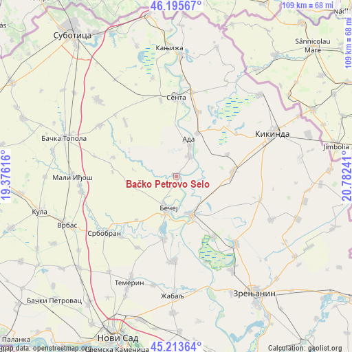
Bačko Petrovo Selo GPS coordinates[2]
45° 42' 24.516" North, 20° 4' 45.408" East
| Map corner | latitude | longitude |
|---|---|---|
| Upper-left | 46.19567°, | 19.37616° |
| Center: | 45.70681°, | 20.07928° |
| Lower-right: | 45.21364°, | 20.78241° |
| Map W x H: | 109.2×109.2 km | = 67.9×67.9mi |
| max Lat: | 46.1° ⇑8.2% North |
| Bačko Petrovo Selo: | 45.70681° |
| min Lat: | ⇓91.8% South 42.25846° |
| min Long | Bačko Petrovo | max Long |
| 18.9276° | 20.07928° | 22.77556° |
| W 35.4%⇐ | ⇒64.6% E |
Elevation
Elevation of Bačko Petrovo Selo is 79 m = 259 ft, and this is 97.4 m = 320 ft below average elevation for this country.
| Max E: |
1421 m = 4662 ft | 71.9% |
| Avg. | 176.4 m = 579 ft | |
| Bačko Petrovo Selo | 79 m = 259 ft | |
Min E: |
49 m = 161 ft | 28.1% |
See also: Serbia elevation on elevation.city.
Geographical zone
Bačko Petrovo Selo is located in North temperate zone (between Tropic of Cancer and the Arctic Circle). Distance of this North polar circle is 2319.1 km =1441 mi to North.| Distance of | km | miles | from Bačko Petrovo Selo |
|---|---|---|---|
| North Pole | 4924.9 | 3060.2 | to North |
| Arctic Circle | 2319.1 | 1441 | to North |
| Tropic Cancer | 2476.2 | 1538.6 | to South |
| Equator | 5082.1 | 3157.9 | to South |


Nearby cities:
15 places around Bačko Petrovo Selo: (largest is in red/bold)
• Ada
11.2 km =7 mi,  18°
18°
• Bačko Gradište
19.7 km =12.2 mi,  191°
191°
• Bečej
10.7 km =6.6 mi,  199°
199°
• Bočar
17.4 km =10.8 mi,  66°
66°
• Gornji Breg
24.2 km =15 mi,  348°
348°
• Jazovo
24 km =14.9 mi,  27°
27°
• Kumane
22 km =13.7 mi,  147°
147°
• Mol
7.7 km =4.8 mi, 32°
• Novi Bečej
12.8 km =8 mi,  160°
160°
• Novo Miloševo
17.5 km =10.9 mi,  85°
85°
• Ostojićevo
21.3 km =13.2 mi, 18°
• Padej
14.9 km =9.3 mi, 25°
• Sajan
21.6 km =13.4 mi,  45°
45°
• Senta
24.5 km =15.2 mi,  359°
359°
• Tiszahegyes
22.8 km =14.2 mi, 54°
Sources, notices
• [Note1] Compared only with cities in Serbia existing in our database
• [Src1] Map data: © OpenStreetMap contributors (CC-BY-SA)
• [Src2] Other city data from geonames.org with taken over terms of usage.
• [Src3] Geographical zone / Annual Mean Temperature by Robert A. Rohde @ Wikipedia
