Ytyk-Kyuyël’ geodata
Ytyk-Kyuyël’ (Sakha) is a populated place; located in Russia in Asia/Yakutsk (GMT+9) time zone. With population of 7,023 people, there are 1993 cities with bigger population in this country. Compared to other cities in Russia, 95.5% of cities are located further ↓South; 96.5% of cities are located further ←West and 60.3% of cities have lower elevation than Ytyk-Kyuyël’. Note1


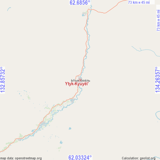
Ytyk-Kyuyël’ GPS coordinates[2]
62° 21' 40.284" North, 133° 33' 37.584" East
| Map corner | latitude | longitude |
|---|---|---|
| Upper-left | 62.6856°, | 132.85732° |
| Center: | 62.36119°, | 133.56044° |
| Lower-right: | 62.03324°, | 134.26357° |
| Map W x H: | 72.5×72.5 km | = 45×45mi |
| max Lat: | 73.50819° ⇑4.5% North |
| Ytyk-Kyuyël’: | 62.36119° |
| min Lat: | ⇓95.5% South 41.28413° |
| min Long | Ytyk-Kyuyël’ | max Long |
| -179.12198° | 133.56044° | 179.35046° |
| W 96.5%⇐ | ⇒3.5% E |
Elevation
Elevation of Ytyk-Kyuyël’ is 169 m = 554 ft, and this is 33.6 m = 110 ft below average elevation for this country.
| Max E: |
2518 m = 8261 ft | 39.7% |
| Avg. | 202.6 m = 665 ft | |
| Ytyk-Kyuyël’ | 169 m = 554 ft | |
Min E: |
-28 m = -92 ft | 60.3% |
See also: Russia elevation on elevation.city.
Geographical zone
Ytyk-Kyuyël’ is located in North temperate zone (between Tropic of Cancer and the Arctic Circle). Distance of this North polar circle is 467.3 km =290.4 mi to North.| Distance of | km | miles | from Ytyk-Kyuyël’ |
|---|---|---|---|
| North Pole | 3073.1 | 1909.5 | to North |
| Arctic Circle | 467.3 | 290.4 | to North |
| Tropic Cancer | 4328 | 2689.3 | to South |
| Equator | 6933.9 | 4308.5 | to South |


Nearby cities:
15 places around Ytyk-Kyuyël’: (largest is in red/bold)
• Amga
182.7 km =113.5 mi,  207°
207°
• Borogontsy
127.7 km =79.3 mi,  285°
285°
• Churapcha
71 km =44.1 mi,  235°
235°
• Dzhebariki-Khaya
119.5 km =74.3 mi,  98°
98°
• Kangalassy
185.5 km =115.3 mi,  269°
269°
• Khandyga
108 km =67.1 mi,  72°
72°
• Khatassy
210.2 km =130.6 mi,  256°
256°
• Markha
199.5 km =124 mi, 262°
• Mayya
184.4 km =114.6 mi,  247°
247°
• Namtsy
203.5 km =126.4 mi,  281°
281°
• Nizhniy Bestyakh
194.5 km =120.9 mi, 256°
• Staraya Tabaga
213 km =132.4 mi, 253°
• Tabaga
213.5 km =132.7 mi, 254°
• Yakutsk
201.8 km =125.4 mi, 259°
• Zhatay
194.4 km =120.8 mi, 263°
Sources, notices
• [Note1] Compared only with cities in Russia existing in our database
• [Src1] Map data: © OpenStreetMap contributors (CC-BY-SA)
• [Src2] Other city data from geonames.org with taken over terms of usage.
• [Src3] Geographical zone / Annual Mean Temperature by Robert A. Rohde @ Wikipedia
