Khatassy geodata
Khatassy (Sakha) is a populated place; located in Russia in Asia/Yakutsk (GMT+9) time zone. With population of 3,676 people, there are 3291 cities with bigger population in this country. Compared to other cities in Russia, 94.6% of cities are located further ↓South; 94.2% of cities are located further ←West and 69.3% of cities have higher elevation than Khatassy. Note1


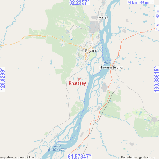
Khatassy GPS coordinates[2]
61° 54' 22.968" North, 129° 37' 58.872" East
| Map corner | latitude | longitude |
|---|---|---|
| Upper-left | 62.2357°, | 128.9299° |
| Center: | 61.90638°, | 129.63302° |
| Lower-right: | 61.57347°, | 130.33615° |
| Map W x H: | 73.6×73.6 km | = 45.7×45.7mi |
| max Lat: | 73.50819° ⇑5.4% North |
| Khatassy: | 61.90638° |
| min Lat: | ⇓94.6% South 41.28413° |
| min Long | Khatassy | max Long |
| -179.12198° | 129.63302° | 179.35046° |
| W 94.2%⇐ | ⇒5.8% E |
Elevation
Elevation of Khatassy is 104 m = 341 ft, and this is 98.6 m = 323 ft below average elevation for this country.
| Max E: |
2518 m = 8261 ft | 69.3% |
| Avg. | 202.6 m = 665 ft | |
| Khatassy | 104 m = 341 ft | |
Min E: |
-28 m = -92 ft | 30.7% |
See also: Russia elevation on elevation.city.
Geographical zone
Khatassy is located in North temperate zone (between Tropic of Cancer and the Arctic Circle). Distance of this North polar circle is 517.8 km =321.7 mi to North.| Distance of | km | miles | from Khatassy |
|---|---|---|---|
| North Pole | 3123.7 | 1941 | to North |
| Arctic Circle | 517.8 | 321.7 | to North |
| Tropic Cancer | 4277.4 | 2657.9 | to South |
| Equator | 6883.3 | 4277.1 | to South |


Nearby cities:
15 places around Khatassy: (largest is in red/bold)
• Berdigestyakh
154.8 km =96.2 mi,  277°
277°
• Borogontsy
116.1 km =72.1 mi,  42°
42°
• Churapcha
146.8 km =91.2 mi,  85°
85°
• Kangalassy
52.1 km =32.4 mi,  19°
19°
• Magan
23 km =14.3 mi,  346°
346°
• Markha
23.9 km =14.9 mi,  14°
14°
• Mayya
38.8 km =24.1 mi,  118°
118°
• Mokhsogollokh
67.6 km =42 mi,  212°
212°
• Namtsy
90.4 km =56.2 mi,  1°
1°
• Nizhniy Bestyakh
15.9 km =9.9 mi,  67°
67°
• Pokrovsk
54.4 km =33.8 mi, 208°
• Staraya Tabaga
9.5 km =5.9 mi,  179°
179°
• Tabaga
6 km =3.7 mi,  196°
196°
• Yakutsk
15.1 km =9.4 mi, 20°
• Zhatay
30 km =18.6 mi, 19°
Sources, notices
• [Note1] Compared only with cities in Russia existing in our database
• [Src1] Map data: © OpenStreetMap contributors (CC-BY-SA)
• [Src2] Other city data from geonames.org with taken over terms of usage.
• [Src3] Geographical zone / Annual Mean Temperature by Robert A. Rohde @ Wikipedia
