Yakutsk geodata
Yakutsk (Sakha) is a seat of a first-order administrative division; located in Russia in Asia/Yakutsk (GMT+9) time zone. With population of 235,600 people, there are 82 cities with bigger population in this country. Compared to other cities in Russia, 94.9% of cities are located further ↓South; 94.2% of cities are located further ←West and 59.2% of cities have higher elevation than Yakutsk. Note1


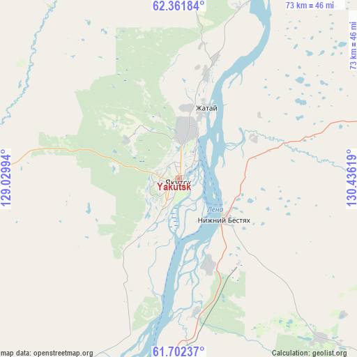
Yakutsk GPS coordinates[2]
62° 2' 2.004" North, 129° 43' 59.016" East
| Map corner | latitude | longitude |
|---|---|---|
| Upper-left | 62.36184°, | 129.02994° |
| Center: | 62.03389°, | 129.73306° |
| Lower-right: | 61.70237°, | 130.43619° |
| Map W x H: | 73.3×73.3 km | = 45.5×45.5mi |
| max Lat: | 73.50819° ⇑5.1% North |
| Yakutsk: | 62.03389° |
| min Lat: | ⇓94.9% South 41.28413° |
| min Long | Yakutsk | max Long |
| -179.12198° | 129.73306° | 179.35046° |
| W 94.2%⇐ | ⇒5.8% E |
Elevation
Elevation of Yakutsk is 126 m = 413 ft, and this is 76.6 m = 251 ft below average elevation for this country.
| Max E: |
2518 m = 8261 ft | 59.2% |
| Avg. | 202.6 m = 665 ft | |
| Yakutsk | 126 m = 413 ft | |
Min E: |
-28 m = -92 ft | 40.8% |
See also: Yakutsk elevation on elevation.city.
Geographical zone
Yakutsk is located in North temperate zone (between Tropic of Cancer and the Arctic Circle). Distance of this North polar circle is 503.7 km =313 mi to North.| Distance of | km | miles | from Yakutsk |
|---|---|---|---|
| North Pole | 3109.5 | 1932.2 | to North |
| Arctic Circle | 503.7 | 313 | to North |
| Tropic Cancer | 4291.6 | 2666.7 | to South |
| Equator | 6897.5 | 4285.9 | to South |


Nearby cities:
15 places around Yakutsk: (largest is in red/bold)
• Berdigestyakh
158.4 km =98.4 mi,  272°
272°
• Borogontsy
102.3 km =63.6 mi,  46°
46°
• Churapcha
140.9 km =87.6 mi,  91°
91°
• Kangalassy
37 km =23 mi,  18°
18°
• Khatassy
15.1 km =9.4 mi,  200°
200°
• Magan
13.3 km =8.3 mi,  307°
307°
• Markha
9 km =5.6 mi,  3°
3°
• Mayya
43.7 km =27.2 mi,  138°
138°
• Mokhsogollokh
82.4 km =51.2 mi,  210°
210°
• Namtsy
76.3 km =47.4 mi,  357°
357°
• Nizhniy Bestyakh
12.3 km =7.6 mi,  130°
130°
• Pokrovsk
69.3 km =43.1 mi, 206°
• Staraya Tabaga
24.2 km =15 mi,  192°
192°
• Tabaga
21.1 km =13.1 mi, 199°
• Zhatay
14.8 km =9.2 mi, 19°
Sources, notices
• [Note1] Compared only with cities in Russia existing in our database
• [Src1] Map data: © OpenStreetMap contributors (CC-BY-SA)
• [Src2] Other city data from geonames.org with taken over terms of usage.
• [Src3] Geographical zone / Annual Mean Temperature by Robert A. Rohde @ Wikipedia
