Utulik geodata
Utulik (Irkutsk Oblast) is a populated place; located in Russia in Asia/Irkutsk (GMT+8) time zone. With population of 1,000 people, there are 4627 cities with bigger population in this country. Compared to other cities in Russia, 72.2% of cities are located further ↑North; 89.4% of cities are located further ←West and 90.4% of cities have lower elevation than Utulik. Note1


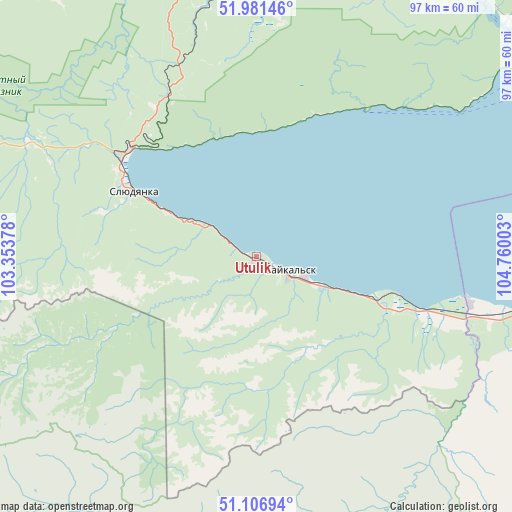
Utulik GPS coordinates[2]
51° 32' 46.68" North, 104° 3' 24.84" East
| Map corner | latitude | longitude |
|---|---|---|
| Upper-left | 51.98146°, | 103.35378° |
| Center: | 51.5463°, | 104.0569° |
| Lower-right: | 51.10694°, | 104.76003° |
| Map W x H: | 97.2×97.2 km | = 60.4×60.4mi |
| max Lat: | 73.50819° ⇑72.2% North |
| Utulik: | 51.5463° |
| min Lat: | ⇓27.8% South 41.28413° |
| min Long | Utulik | max Long |
| -179.12198° | 104.0569° | 179.35046° |
| W 89.4%⇐ | ⇒10.6% E |
Elevation
Elevation of Utulik is 461 m = 1512 ft, and this is 258.4 m = 848 ft above average elevation for this country.
| Max E: |
2518 m = 8261 ft | 9.6% |
| Utulik | 461 m 1512 ft | |
| Avg. | 202.6 m = 665 ft | |
Min E: |
-28 m = -92 ft | 90.4% |
See also: Russia elevation on elevation.city.
Geographical zone
Utulik is located in North temperate zone (between Tropic of Cancer and the Arctic Circle). Distance of this North polar circle is 1669.8 km =1037.6 mi to North.| Distance of | km | miles | from Utulik |
|---|---|---|---|
| North Pole | 4275.7 | 2656.8 | to North |
| Arctic Circle | 1669.8 | 1037.6 | to North |
| Tropic Cancer | 3125.5 | 1942.1 | to South |
| Equator | 5731.4 | 3561.3 | to South |


Nearby cities:
15 places around Utulik: (largest is in red/bold)
• Baykal’sk
6.7 km =4.2 mi,  121°
121°
• Bol’shaya Rechka
65 km =40.4 mi,  45°
45°
• Chistyye Klyuchi
70.9 km =44.1 mi,  353°
353°
• Kultuk
31.6 km =19.6 mi,  307°
307°
• Listvyanka
65.6 km =40.8 mi,  58°
58°
• Markova
74.4 km =46.2 mi,  8°
8°
• Moty
59.8 km =37.2 mi, 349°
• Pad’ Mel’nichnaya
71.8 km =44.6 mi,  18°
18°
• Rechka-Vydrino
54.8 km =34.1 mi,  96°
96°
• Shamanka
60.1 km =37.3 mi,  344°
344°
• Shelekhov
74.3 km =46.2 mi,  2°
2°
• Slyudyanka
27.3 km =17 mi,  297°
297°
• Tankhoy
73.9 km =45.9 mi,  89°
89°
• Vvedenshchina
73.9 km =45.9 mi, 353°
• Vydrino
41.6 km =25.8 mi, 102°
Sources, notices
• [Note1] Compared only with cities in Russia existing in our database
• [Src1] Map data: © OpenStreetMap contributors (CC-BY-SA)
• [Src2] Other city data from geonames.org with taken over terms of usage.
• [Src3] Geographical zone / Annual Mean Temperature by Robert A. Rohde @ Wikipedia
