Listvyanka geodata
Listvyanka (Irkutsk Oblast) is a populated place; located in Russia in Asia/Irkutsk (GMT+8) time zone. With population of 1,700 people, there are 4290 cities with bigger population in this country. Compared to other cities in Russia, 70% of cities are located further ↑North; 89.8% of cities are located further ←West and 93.4% of cities have lower elevation than Listvyanka. Note1


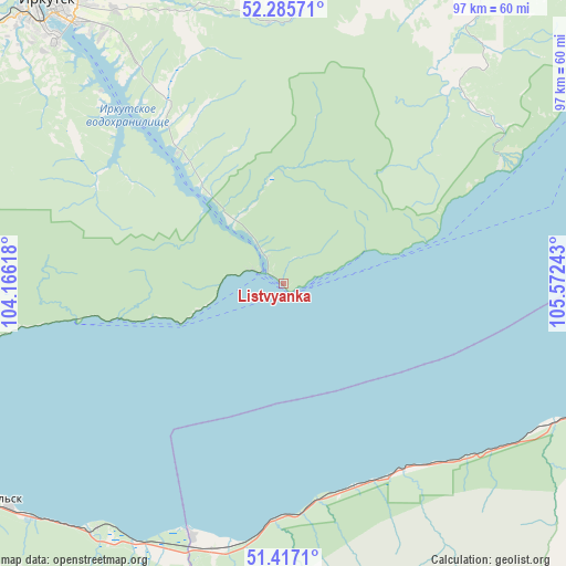
Listvyanka GPS coordinates[2]
51° 51' 12.6" North, 104° 52' 9.48" East
| Map corner | latitude | longitude |
|---|---|---|
| Upper-left | 52.28571°, | 104.16618° |
| Center: | 51.8535°, | 104.8693° |
| Lower-right: | 51.4171°, | 105.57243° |
| Map W x H: | 96.6×96.6 km | = 60×60mi |
| max Lat: | 73.50819° ⇑70% North |
| Listvyanka: | 51.8535° |
| min Lat: | ⇓30% South 41.28413° |
| min Long | Listvyanka | max Long |
| -179.12198° | 104.8693° | 179.35046° |
| W 89.8%⇐ | ⇒10.2% E |
Elevation
Elevation of Listvyanka is 554 m = 1818 ft, and this is 351.4 m = 1153 ft above average elevation for this country.
| Max E: |
2518 m = 8261 ft | 6.6% |
| Listvyanka | 554 m 1818 ft | |
| Avg. | 202.6 m = 665 ft | |
Min E: |
-28 m = -92 ft | 93.4% |
See also: Russia elevation on elevation.city.
Geographical zone
Listvyanka is located in North temperate zone (between Tropic of Cancer and the Arctic Circle). Distance of this North polar circle is 1635.6 km =1016.3 mi to North.| Distance of | km | miles | from Listvyanka |
|---|---|---|---|
| North Pole | 4241.5 | 2635.5 | to North |
| Arctic Circle | 1635.6 | 1016.3 | to North |
| Tropic Cancer | 3159.6 | 1963.3 | to South |
| Equator | 5765.6 | 3582.6 | to South |


Nearby cities:
15 places around Listvyanka: (largest is in red/bold)
• Baykal’sk
62.8 km =39 mi,  233°
233°
• Bol’shaya Rechka
14.5 km =9 mi,  320°
320°
• Bol’shoye Goloustnoye
42.3 km =26.3 mi,  60°
60°
• Dzerzhinsk
57.8 km =35.9 mi,  325°
325°
• Irkutsk
63 km =39.1 mi, 321°
• Markova
59.9 km =37.2 mi,  311°
311°
• Novolisikha
50.7 km =31.5 mi, 325°
• Pad’ Mel’nichnaya
47.8 km =29.7 mi, 315°
• Pivovarikha
54.7 km =34 mi, 328°
• Rechka-Vydrino
40.5 km =25.2 mi,  182°
182°
• Shelekhov
66.1 km =41.1 mi, 307°
• Smolenshchina
67.6 km =42 mi, 311°
• Tankhoy
37.4 km =23.2 mi,  151°
151°
• Utulik
65.6 km =40.8 mi,  238°
238°
• Vydrino
46.2 km =28.7 mi,  199°
199°
Sources, notices
• [Note1] Compared only with cities in Russia existing in our database
• [Src1] Map data: © OpenStreetMap contributors (CC-BY-SA)
• [Src2] Other city data from geonames.org with taken over terms of usage.
• [Src3] Geographical zone / Annual Mean Temperature by Robert A. Rohde @ Wikipedia
