Rechka-Vydrino geodata
Rechka-Vydrino (Buryatiya Republic) is a populated place; located in Russia in Asia/Irkutsk (GMT+8) time zone. With population of 5,211 people, there are 2553 cities with bigger population in this country. Compared to other cities in Russia, 72.6% of cities are located further ↑North; 89.7% of cities are located further ←West and 90.3% of cities have lower elevation than Rechka-Vydrino. Note1


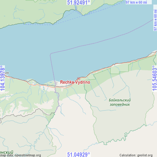
Rechka-Vydrino GPS coordinates[2]
51° 29' 21.12" North, 104° 50' 34.44" East
| Map corner | latitude | longitude |
|---|---|---|
| Upper-left | 51.92491°, | 104.13978° |
| Center: | 51.4892°, | 104.8429° |
| Lower-right: | 51.04929°, | 105.54603° |
| Map W x H: | 97.4×97.4 km | = 60.5×60.5mi |
| max Lat: | 73.50819° ⇑72.6% North |
| Rechka-Vydrino: | 51.4892° |
| min Lat: | ⇓27.4% South 41.28413° |
| min Long | Rechka-Vydrino | max Long |
| -179.12198° | 104.8429° | 179.35046° |
| W 89.7%⇐ | ⇒10.3% E |
Elevation
Elevation of Rechka-Vydrino is 459 m = 1506 ft, and this is 256.4 m = 841 ft above average elevation for this country.
| Max E: |
2518 m = 8261 ft | 9.7% |
| Rechka-Vydrino | 459 m 1506 ft | |
| Avg. | 202.6 m = 665 ft | |
Min E: |
-28 m = -92 ft | 90.3% |
See also: Russia elevation on elevation.city.
Geographical zone
Rechka-Vydrino is located in North temperate zone (between Tropic of Cancer and the Arctic Circle). Distance of this North polar circle is 1676.1 km =1041.5 mi to North.| Distance of | km | miles | from Rechka-Vydrino |
|---|---|---|---|
| North Pole | 4282 | 2660.7 | to North |
| Arctic Circle | 1676.1 | 1041.5 | to North |
| Tropic Cancer | 3119.1 | 1938.1 | to South |
| Equator | 5725.1 | 3557.4 | to South |


Nearby cities:
15 places around Rechka-Vydrino: (largest is in red/bold)
• Babushkin
74.8 km =46.5 mi,  70°
70°
• Baykal’sk
48.7 km =30.3 mi,  273°
273°
• Bol’shaya Rechka
52.2 km =32.4 mi,  351°
351°
• Bol’shoye Goloustnoye
72.5 km =45 mi,  32°
32°
• Kultuk
83.3 km =51.8 mi,  288°
288°
• Listvyanka
40.5 km =25.2 mi,  2°
2°
• Markova
91 km =56.5 mi,  331°
331°
• Moty
91.9 km =57.1 mi,  315°
315°
• Novolisikha
86.7 km =53.9 mi,  341°
341°
• Pad’ Mel’nichnaya
81.1 km =50.4 mi, 336°
• Pivovarikha
91.1 km =56.6 mi, 342°
• Slyudyanka
80.8 km =50.2 mi,  283°
283°
• Tankhoy
21 km =13 mi, 69°
• Utulik
54.8 km =34.1 mi, 276°
• Vydrino
14.2 km =8.8 mi,  258°
258°
Sources, notices
• [Note1] Compared only with cities in Russia existing in our database
• [Src1] Map data: © OpenStreetMap contributors (CC-BY-SA)
• [Src2] Other city data from geonames.org with taken over terms of usage.
• [Src3] Geographical zone / Annual Mean Temperature by Robert A. Rohde @ Wikipedia
