Smolenka geodata
Smolenka (Transbaikal Territory) is a populated place; located in Russia in Asia/Chita (GMT+9) time zone. With population of 2,933 people, there are 3813 cities with bigger population in this country. Compared to other cities in Russia, 68.4% of cities are located further ↑North; 91.7% of cities are located further ←West and 95.6% of cities have lower elevation than Smolenka. Note1


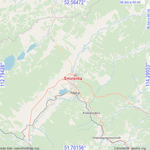
Smolenka GPS coordinates[2]
52° 8' 6.828" North, 113° 29' 50.64" East
| Map corner | latitude | longitude |
|---|---|---|
| Upper-left | 52.56472°, | 112.79428° |
| Center: | 52.13523°, | 113.4974° |
| Lower-right: | 51.70156°, | 114.20053° |
| Map W x H: | 96×96 km | = 59.7×59.7mi |
| max Lat: | 73.50819° ⇑68.4% North |
| Smolenka: | 52.13523° |
| min Lat: | ⇓31.6% South 41.28413° |
| min Long | Smolenka | max Long |
| -179.12198° | 113.4974° | 179.35046° |
| W 91.7%⇐ | ⇒8.3% E |
Elevation
Elevation of Smolenka is 672 m = 2205 ft, and this is 469.4 m = 1540 ft above average elevation for this country.
| Max E: |
2518 m = 8261 ft | 4.4% |
| Smolenka | 672 m 2205 ft | |
| Avg. | 202.6 m = 665 ft | |
Min E: |
-28 m = -92 ft | 95.6% |
See also: Russia elevation on elevation.city.
Geographical zone
Smolenka is located in North temperate zone (between Tropic of Cancer and the Arctic Circle). Distance of this North polar circle is 1604.3 km =996.9 mi to North.| Distance of | km | miles | from Smolenka |
|---|---|---|---|
| North Pole | 4210.2 | 2616.1 | to North |
| Arctic Circle | 1604.3 | 996.9 | to North |
| Tropic Cancer | 3191 | 1982.8 | to South |
| Equator | 5796.9 | 3602 | to South |


Nearby cities:
15 places around Smolenka: (largest is in red/bold)
• Aginskoye
135.4 km =84.1 mi,  148°
148°
• Atamanovka
24.3 km =15.1 mi,  157°
157°
• Bol’shaya Tura
71.5 km =44.4 mi,  143°
143°
• Chita
11.5 km =7.1 mi,  178°
178°
• Darasun
62.2 km =38.6 mi, 148°
• Domna
35.3 km =21.9 mi,  221°
221°
• Drovyanaya
69.6 km =43.2 mi,  206°
206°
• Karymskoye
82.2 km =51.1 mi,  134°
134°
• Kurort-Darasun
105.2 km =65.4 mi,  171°
171°
• Makkaveyevo
52.4 km =32.6 mi, 144°
• Mogzon
113.8 km =70.7 mi,  247°
247°
• Novokruchininskiy
43.5 km =27 mi, 153°
• Ulety
111.2 km =69.1 mi, 218°
• Verkh-Usugli
129.4 km =80.4 mi,  60°
60°
• Yablonovo
59.8 km =37.2 mi,  237°
237°
Sources, notices
• [Note1] Compared only with cities in Russia existing in our database
• [Src1] Map data: © OpenStreetMap contributors (CC-BY-SA)
• [Src2] Other city data from geonames.org with taken over terms of usage.
• [Src3] Geographical zone / Annual Mean Temperature by Robert A. Rohde @ Wikipedia
