Ulety geodata
Ulety (Transbaikal Territory) is a populated place; located in Russia in Asia/Chita (GMT+9) time zone. With population of 6,075 people, there are 2234 cities with bigger population in this country. Compared to other cities in Russia, 73.3% of cities are located further ↑North; 91.5% of cities are located further ←West and 96.6% of cities have lower elevation than Ulety. Note1


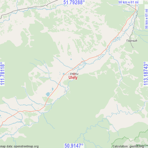
Ulety GPS coordinates[2]
51° 21' 21.204" North, 112° 29' 3.48" East
| Map corner | latitude | longitude |
|---|---|---|
| Upper-left | 51.79288°, | 111.78118° |
| Center: | 51.35589°, | 112.4843° |
| Lower-right: | 50.9147°, | 113.18743° |
| Map W x H: | 97.6×97.6 km | = 60.6×60.6mi |
| max Lat: | 73.50819° ⇑73.3% North |
| Ulety: | 51.35589° |
| min Lat: | ⇓26.7% South 41.28413° |
| min Long | Ulety | max Long |
| -179.12198° | 112.4843° | 179.35046° |
| W 91.5%⇐ | ⇒8.5% E |
Elevation
Elevation of Ulety is 740 m = 2428 ft, and this is 537.4 m = 1763 ft above average elevation for this country.
| Max E: |
2518 m = 8261 ft | 3.4% |
| Ulety | 740 m 2428 ft | |
| Avg. | 202.6 m = 665 ft | |
Min E: |
-28 m = -92 ft | 96.6% |
See also: Russia elevation on elevation.city.
Geographical zone
Ulety is located in North temperate zone (between Tropic of Cancer and the Arctic Circle). Distance of this North polar circle is 1690.9 km =1050.7 mi to North.| Distance of | km | miles | from Ulety |
|---|---|---|---|
| North Pole | 4296.8 | 2669.9 | to North |
| Arctic Circle | 1690.9 | 1050.7 | to North |
| Tropic Cancer | 3104.3 | 1928.9 | to South |
| Equator | 5710.2 | 3548.2 | to South |


Nearby cities:
15 places around Ulety: (largest is in red/bold)
• Aksha
132.1 km =82.1 mi,  154°
154°
• Atamanovka
102 km =63.4 mi,  50°
50°
• Bol’shaya Tura
116.4 km =72.3 mi,  75°
75°
• Chita
102.7 km =63.8 mi,  42°
42°
• Darasun
108.6 km =67.5 mi,  71°
71°
• Domna
76 km =47.2 mi, 37°
• Drovyanaya
45.7 km =28.4 mi,  57°
57°
• Dul’durga
108.3 km =67.3 mi,  134°
134°
• Karymskoye
132.4 km =82.3 mi, 77°
• Kurort-Darasun
87.4 km =54.3 mi,  101°
101°
• Makkaveyevo
110.2 km =68.5 mi, 66°
• Mogzon
55.8 km =34.7 mi,  320°
320°
• Novokruchininskiy
101.1 km =62.8 mi, 61°
• Smolenka
111.2 km =69.1 mi, 38°
• Yablonovo
57.5 km =35.7 mi,  19°
19°
Sources, notices
• [Note1] Compared only with cities in Russia existing in our database
• [Src1] Map data: © OpenStreetMap contributors (CC-BY-SA)
• [Src2] Other city data from geonames.org with taken over terms of usage.
• [Src3] Geographical zone / Annual Mean Temperature by Robert A. Rohde @ Wikipedia
