Neryungri geodata
Neryungri (Sakha) is a populated place; located in Russia in Asia/Yakutsk (GMT+9) time zone. With population of 66,320 people, there are 308 cities with bigger population in this country. Compared to other cities in Russia, 74.1% of cities are located further ↓South; 93.3% of cities are located further ←West and 96.7% of cities have lower elevation than Neryungri. Note1


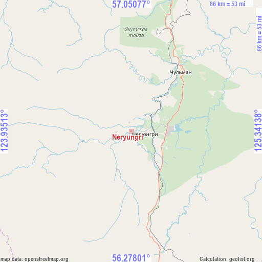
Neryungri GPS coordinates[2]
56° 39' 58.932" North, 124° 38' 17.7" East
| Map corner | latitude | longitude |
|---|---|---|
| Upper-left | 57.05077°, | 123.93513° |
| Center: | 56.66637°, | 124.63825° |
| Lower-right: | 56.27801°, | 125.34138° |
| Map W x H: | 85.9×85.9 km | = 53.4×53.4mi |
| max Lat: | 73.50819° ⇑25.9% North |
| Neryungri: | 56.66637° |
| min Lat: | ⇓74.1% South 41.28413° |
| min Long | Neryungri | max Long |
| -179.12198° | 124.63825° | 179.35046° |
| W 93.3%⇐ | ⇒6.7% E |
Elevation
Elevation of Neryungri is 749 m = 2457 ft, and this is 546.4 m = 1793 ft above average elevation for this country.
| Max E: |
2518 m = 8261 ft | 3.3% |
| Neryungri | 749 m 2457 ft | |
| Avg. | 202.6 m = 665 ft | |
Min E: |
-28 m = -92 ft | 96.7% |
See also: Neryungri elevation on elevation.city.
Geographical zone
Neryungri is located in North temperate zone (between Tropic of Cancer and the Arctic Circle). Distance of this North polar circle is 1100.5 km =683.8 mi to North.| Distance of | km | miles | from Neryungri |
|---|---|---|---|
| North Pole | 3706.4 | 2303 | to North |
| Arctic Circle | 1100.5 | 683.8 | to North |
| Tropic Cancer | 3694.8 | 2295.8 | to South |
| Equator | 6300.7 | 3915.1 | to South |


Nearby cities:
15 places around Neryungri: (largest is in red/bold)
• Aldan
220.8 km =137.2 mi,  11°
11°
• Berkakit
13.3 km =8.3 mi,  140°
140°
• Chul’man
26 km =16.2 mi,  39°
39°
• Khani
224.8 km =139.7 mi,  280°
280°
• Lebedinyy
208.9 km =129.8 mi, 14°
• Leninskiy
217.1 km =134.9 mi, 12°
• Never
300.3 km =186.6 mi,  185°
185°
• Nizhniy Kuranakh
245.6 km =152.6 mi, 12°
• Serebryanyy Bor
12.2 km =7.6 mi,  87°
87°
• Skovorodino
301.4 km =187.3 mi, 188°
• Solovjevsk
270.8 km =168.3 mi,  182°
182°
• Takhtamygda
291.6 km =181.2 mi, 192°
• Tommot
272.9 km =169.6 mi,  21°
21°
• Tynda
168 km =104.4 mi, 178°
• Zolotinka
55.4 km =34.4 mi,  165°
165°
Sources, notices
• [Note1] Compared only with cities in Russia existing in our database
• [Src1] Map data: © OpenStreetMap contributors (CC-BY-SA)
• [Src2] Other city data from geonames.org with taken over terms of usage.
• [Src3] Geographical zone / Annual Mean Temperature by Robert A. Rohde @ Wikipedia
