Leninskiy geodata
Leninskiy (Sakha) is a populated place; located in Russia in Asia/Yakutsk (GMT+9) time zone. With population of 2,043 people, there are 4132 cities with bigger population in this country. Compared to other cities in Russia, 85.1% of cities are located further ↓South; 93.5% of cities are located further ←West and 94.6% of cities have lower elevation than Leninskiy. Note1


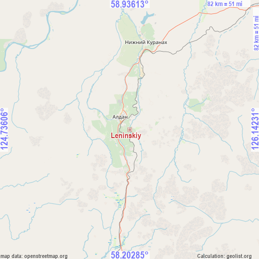
Leninskiy GPS coordinates[2]
58° 34' 17.076" North, 125° 26' 21.048" East
| Map corner | latitude | longitude |
|---|---|---|
| Upper-left | 58.93613°, | 124.73606° |
| Center: | 58.57141°, | 125.43918° |
| Lower-right: | 58.20285°, | 126.14231° |
| Map W x H: | 81.5×81.5 km | = 50.6×50.6mi |
| max Lat: | 73.50819° ⇑14.9% North |
| Leninskiy: | 58.57141° |
| min Lat: | ⇓85.1% South 41.28413° |
| min Long | Leninskiy | max Long |
| -179.12198° | 125.43918° | 179.35046° |
| W 93.5%⇐ | ⇒6.5% E |
Elevation
Elevation of Leninskiy is 611 m = 2005 ft, and this is 408.4 m = 1340 ft above average elevation for this country.
| Max E: |
2518 m = 8261 ft | 5.4% |
| Leninskiy | 611 m 2005 ft | |
| Avg. | 202.6 m = 665 ft | |
Min E: |
-28 m = -92 ft | 94.6% |
See also: Russia elevation on elevation.city.
Geographical zone
Leninskiy is located in North temperate zone (between Tropic of Cancer and the Arctic Circle). Distance of this North polar circle is 888.6 km =552.2 mi to North.| Distance of | km | miles | from Leninskiy |
|---|---|---|---|
| North Pole | 3494.5 | 2171.4 | to North |
| Arctic Circle | 888.6 | 552.2 | to North |
| Tropic Cancer | 3906.6 | 2427.4 | to South |
| Equator | 6512.5 | 4046.7 | to South |


Nearby cities:
11 places around Leninskiy: (largest is in red/bold)
• Aldan
5 km =3.1 mi,  329°
329°
• Berdigestyakh
398.2 km =247.4 mi,  9°
9°
• Berkakit
225.5 km =140.1 mi,  190°
190°
• Chul’man
194.3 km =120.7 mi, 189°
• Lebedinyy
9.8 km =6.1 mi,  160°
160°
• Neryungri
217.1 km =134.9 mi, 192°
• Nizhniy Kuranakh
28.5 km =17.7 mi, 9°
• Serebryanyy Bor
214.3 km =133.2 mi, 189°
• Tommot
65.2 km =40.5 mi,  48°
48°
• Tynda
382.2 km =237.5 mi, 186°
• Zolotinka
267.7 km =166.3 mi, 187°
Sources, notices
• [Note1] Compared only with cities in Russia existing in our database
• [Src1] Map data: © OpenStreetMap contributors (CC-BY-SA)
• [Src2] Other city data from geonames.org with taken over terms of usage.
• [Src3] Geographical zone / Annual Mean Temperature by Robert A. Rohde @ Wikipedia
