Tynda geodata
Tynda (Amur Oblast) is a populated place; located in Russia in Asia/Yakutsk (GMT+9) time zone. With population of 37,335 people, there are 557 cities with bigger population in this country. Compared to other cities in Russia, 54.9% of cities are located further ↓South; 93.4% of cities are located further ←West and 93.2% of cities have lower elevation than Tynda. Note1


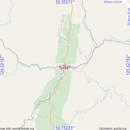
Tynda GPS coordinates[2]
55° 9' 21.6" North, 124° 43' 29.244" East
| Map corner | latitude | longitude |
|---|---|---|
| Upper-left | 55.55571°, | 124.02167° |
| Center: | 55.156°, | 124.72479° |
| Lower-right: | 54.75225°, | 125.42792° |
| Map W x H: | 89.3×89.3 km | = 55.5×55.5mi |
| max Lat: | 73.50819° ⇑45.1% North |
| Tynda: | 55.156° |
| min Lat: | ⇓54.9% South 41.28413° |
| min Long | Tynda | max Long |
| -179.12198° | 124.72479° | 179.35046° |
| W 93.4%⇐ | ⇒6.6% E |
Elevation
Elevation of Tynda is 547 m = 1795 ft, and this is 344.4 m = 1130 ft above average elevation for this country.
| Max E: |
2518 m = 8261 ft | 6.8% |
| Tynda | 547 m 1795 ft | |
| Avg. | 202.6 m = 665 ft | |
Min E: |
-28 m = -92 ft | 93.2% |
See also: Russia elevation on elevation.city.
Geographical zone
Tynda is located in North temperate zone (between Tropic of Cancer and the Arctic Circle). Distance of this North polar circle is 1268.4 km =788.1 mi to North.| Distance of | km | miles | from Tynda |
|---|---|---|---|
| North Pole | 3874.3 | 2407.4 | to North |
| Arctic Circle | 1268.4 | 788.1 | to North |
| Tropic Cancer | 3526.9 | 2191.5 | to South |
| Equator | 6132.8 | 3810.7 | to South |


Nearby cities:
15 places around Tynda: (largest is in red/bold)
• Berkakit
157.8 km =98.1 mi,  1°
1°
• Chul’man
188.4 km =117.1 mi, 3°
• Magdagachi
201.9 km =125.5 mi,  159°
159°
• Neryungri
168 km =104.4 mi,  358°
358°
• Never
135.8 km =84.4 mi,  195°
195°
• Ovsyanka
224.8 km =139.7 mi,  141°
141°
• Serebryanyy Bor
168.6 km =104.8 mi, 2°
• Skovorodino
139.7 km =86.8 mi, 201°
• Solovjevsk
104.3 km =64.8 mi,  190°
190°
• Takhtamygda
136.7 km =84.9 mi,  211°
211°
• Taldan
163.1 km =101.3 mi,  177°
177°
• Urusha
170.5 km =105.9 mi,  224°
224°
• Yerofey Pavlovich
222.3 km =138.1 mi,  233°
233°
• Zeya
227.4 km =141.3 mi,  133°
133°
• Zolotinka
114.6 km =71.2 mi, 4°
Sources, notices
• [Note1] Compared only with cities in Russia existing in our database
• [Src1] Map data: © OpenStreetMap contributors (CC-BY-SA)
• [Src2] Other city data from geonames.org with taken over terms of usage.
• [Src3] Geographical zone / Annual Mean Temperature by Robert A. Rohde @ Wikipedia
