Khurba geodata
Khurba (Khabarovsk) is a populated place; located in Russia in Asia/Vladivostok (GMT+10) time zone. With population of 5,537 people, there are 2426 cities with bigger population in this country. Compared to other cities in Russia, 76.9% of cities are located further ↑North; 97.5% of cities are located further ←West and 85.6% of cities have higher elevation than Khurba. Note1


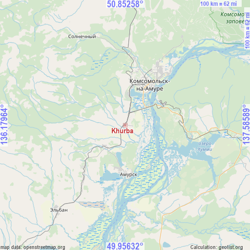
Khurba GPS coordinates[2]
50° 24' 23.652" North, 136° 52' 57.936" East
| Map corner | latitude | longitude |
|---|---|---|
| Upper-left | 50.85258°, | 136.17964° |
| Center: | 50.40657°, | 136.88276° |
| Lower-right: | 49.95632°, | 137.58589° |
| Map W x H: | 99.7×99.7 km | = 62×62mi |
| max Lat: | 73.50819° ⇑76.9% North |
| Khurba: | 50.40657° |
| min Lat: | ⇓23.1% South 41.28413° |
| min Long | Khurba | max Long |
| -179.12198° | 136.88276° | 179.35046° |
| W 97.5%⇐ | ⇒2.5% E |
Elevation
Elevation of Khurba is 45 m = 148 ft, and this is 157.6 m = 517 ft below average elevation for this country.
| Max E: |
2518 m = 8261 ft | 85.6% |
| Avg. | 202.6 m = 665 ft | |
| Khurba | 45 m = 148 ft | |
Min E: |
-28 m = -92 ft | 14.4% |
See also: Russia elevation on elevation.city.
Geographical zone
Khurba is located in North temperate zone (between Tropic of Cancer and the Arctic Circle). Distance of this North polar circle is 1796.5 km =1116.3 mi to North.| Distance of | km | miles | from Khurba |
|---|---|---|---|
| North Pole | 4402.4 | 2735.5 | to North |
| Arctic Circle | 1796.5 | 1116.3 | to North |
| Tropic Cancer | 2998.8 | 1863.4 | to South |
| Equator | 5604.7 | 3482.6 | to South |


Nearby cities:
15 places around Khurba: (largest is in red/bold)
• Amursk
18.9 km =11.7 mi,  180°
180°
• Berëzovyy
164.1 km =102 mi,  328°
328°
• Gorin
89.4 km =55.6 mi,  350°
350°
• Gornyy
50.1 km =31.1 mi,  322°
322°
• Gurskoye
86.4 km =53.7 mi,  96°
96°
• Imeni Poliny Osipenko
225.8 km =140.3 mi, 353°
• Knyaze-Volkonskoye
239.2 km =148.6 mi,  205°
205°
• Komsomolsk-on-Amur
18.3 km =11.4 mi,  29°
29°
• Litovko
178.7 km =111 mi,  223°
223°
• Selikhino
44.1 km =27.4 mi, 95°
• Sinda
166 km =103.1 mi,  194°
194°
• Solnechnyy
22.4 km =13.9 mi, 28°
• Solnechnyy
39.3 km =24.4 mi, 333°
• Tsimmermanovka
195.9 km =121.7 mi,  57°
57°
• Vysokogornyy
162.9 km =101.2 mi, 102°
Sources, notices
• [Note1] Compared only with cities in Russia existing in our database
• [Src1] Map data: © OpenStreetMap contributors (CC-BY-SA)
• [Src2] Other city data from geonames.org with taken over terms of usage.
• [Src3] Geographical zone / Annual Mean Temperature by Robert A. Rohde @ Wikipedia
