Kogalym geodata
Kogalym (Khanty-Mansia) is a populated place; located in Russia in Asia/Yekaterinburg (GMT+5) time zone. With population of 57,800 people, there are 364 cities with bigger population in this country. Compared to other cities in Russia, 95.4% of cities are located further ↓South; 78.1% of cities are located further ←West and 73.4% of cities have higher elevation than Kogalym. Note1


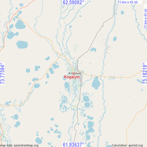
Kogalym GPS coordinates[2]
62° 15' 55.332" North, 74° 28' 44.616" East
| Map corner | latitude | longitude |
|---|---|---|
| Upper-left | 62.59082°, | 73.77594° |
| Center: | 62.26537°, | 74.47906° |
| Lower-right: | 61.93637°, | 75.18219° |
| Map W x H: | 72.8×72.8 km | = 45.2×45.2mi |
| max Lat: | 73.50819° ⇑4.6% North |
| Kogalym: | 62.26537° |
| min Lat: | ⇓95.4% South 41.28413° |
| min Long | Kogalym | max Long |
| -179.12198° | 74.47906° | 179.35046° |
| W 78.1%⇐ | ⇒21.9% E |
Elevation
Elevation of Kogalym is 93 m = 305 ft, and this is 109.6 m = 360 ft below average elevation for this country.
| Max E: |
2518 m = 8261 ft | 73.4% |
| Avg. | 202.6 m = 665 ft | |
| Kogalym | 93 m = 305 ft | |
Min E: |
-28 m = -92 ft | 26.6% |
See also: Kogalym elevation on elevation.city.
Geographical zone
Kogalym is located in North temperate zone (between Tropic of Cancer and the Arctic Circle). Distance of this North polar circle is 477.9 km =297 mi to North.| Distance of | km | miles | from Kogalym |
|---|---|---|---|
| North Pole | 3083.8 | 1916.2 | to North |
| Arctic Circle | 477.9 | 297 | to North |
| Tropic Cancer | 4317.3 | 2682.6 | to South |
| Equator | 6923.3 | 4301.9 | to South |


Nearby cities:
15 places around Kogalym: (largest is in red/bold)
• Barsovo
140.4 km =87.2 mi,  209°
209°
• Fedorovskiy
83.5 km =51.9 mi, 208°
• Langepas
118.8 km =73.8 mi,  161°
161°
• Lokosovo
127.1 km =79 mi,  171°
171°
• Lyantor
141.1 km =87.7 mi,  239°
239°
• Nizhnesortymskiy
141.6 km =88 mi,  277°
277°
• Novoagansk
119 km =73.9 mi,  107°
107°
• Noyabrsk
114.1 km =70.9 mi,  25°
25°
• Pokachi
76.4 km =47.5 mi,  142°
142°
• Poykovskiy
129.6 km =80.5 mi, 207°
• Raduzhny
156.6 km =97.3 mi,  96°
96°
• Russkinskiye
47.2 km =29.3 mi,  254°
254°
• Singapay
156.3 km =97.1 mi,  217°
217°
• Solnechniy
129.1 km =80.2 mi, 211°
• Surgut
126 km =78.3 mi, 206°
Sources, notices
• [Note1] Compared only with cities in Russia existing in our database
• [Src1] Map data: © OpenStreetMap contributors (CC-BY-SA)
• [Src2] Other city data from geonames.org with taken over terms of usage.
• [Src3] Geographical zone / Annual Mean Temperature by Robert A. Rohde @ Wikipedia
