Solnechniy geodata
Solnechniy (Khanty-Mansia) is a populated place; located in Russia in Asia/Yekaterinburg (GMT+5) time zone. With population of 10,103 people, there are 1493 cities with bigger population in this country. Compared to other cities in Russia, 93.6% of cities are located further ↓South; 77.7% of cities are located further ←West and 84.6% of cities have higher elevation than Solnechniy. Note1


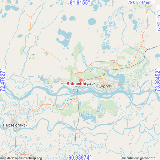
Solnechniy GPS coordinates[2]
61° 16' 45.984" North, 73° 10' 53.004" East
| Map corner | latitude | longitude |
|---|---|---|
| Upper-left | 61.6155°, | 72.47827° |
| Center: | 61.27944°, | 73.18139° |
| Lower-right: | 60.93974°, | 73.88452° |
| Map W x H: | 75.1×75.1 km | = 46.7×46.7mi |
| max Lat: | 73.50819° ⇑6.4% North |
| Solnechniy: | 61.27944° |
| min Lat: | ⇓93.6% South 41.28413° |
| min Long | Solnechniy | max Long |
| -179.12198° | 73.18139° | 179.35046° |
| W 77.7%⇐ | ⇒22.3% E |
Elevation
Elevation of Solnechniy is 49 m = 161 ft, and this is 153.6 m = 504 ft below average elevation for this country.
| Max E: |
2518 m = 8261 ft | 84.6% |
| Avg. | 202.6 m = 665 ft | |
| Solnechniy | 49 m = 161 ft | |
Min E: |
-28 m = -92 ft | 15.4% |
See also: Russia elevation on elevation.city.
Geographical zone
Solnechniy is located in North temperate zone (between Tropic of Cancer and the Arctic Circle). Distance of this North polar circle is 587.5 km =365.1 mi to North.| Distance of | km | miles | from Solnechniy |
|---|---|---|---|
| North Pole | 3193.4 | 1984.3 | to North |
| Arctic Circle | 587.5 | 365.1 | to North |
| Tropic Cancer | 4207.7 | 2614.5 | to South |
| Equator | 6813.6 | 4233.8 | to South |


Nearby cities:
15 places around Solnechniy: (largest is in red/bold)
• Barsovo
12.6 km =7.8 mi,  183°
183°
• Fedorovskiy
46.1 km =28.6 mi,  37°
37°
• Kogalym
129.1 km =80.2 mi,  31°
31°
• Langepas
108.6 km =67.5 mi,  91°
91°
• Lokosovo
89.1 km =55.4 mi,  100°
100°
• Lyantor
66.3 km =41.2 mi,  304°
304°
• Megion
159.7 km =99.2 mi, 100°
• Nefteyugansk
36.8 km =22.9 mi,  237°
237°
• Nizhnesortymskiy
149 km =92.6 mi,  329°
329°
• Pokachi
125.9 km =78.2 mi,  67°
67°
• Poykovskiy
9.6 km =6 mi,  122°
122°
• Pyt-Yakh
61.4 km =38.2 mi,  196°
196°
• Russkinskiye
99.7 km =62 mi,  12°
12°
• Singapay
31.1 km =19.3 mi, 243°
• Surgut
13 km =8.1 mi, 104°
Sources, notices
• [Note1] Compared only with cities in Russia existing in our database
• [Src1] Map data: © OpenStreetMap contributors (CC-BY-SA)
• [Src2] Other city data from geonames.org with taken over terms of usage.
• [Src3] Geographical zone / Annual Mean Temperature by Robert A. Rohde @ Wikipedia
