Pokachi geodata
Pokachi (Khanty-Mansia) is a populated place; located in Russia in Asia/Yekaterinburg (GMT+5) time zone. With population of 17,084 people, there are 994 cities with bigger population in this country. Compared to other cities in Russia, 94.3% of cities are located further ↓South; 78.3% of cities are located further ←West and 83.7% of cities have higher elevation than Pokachi. Note1


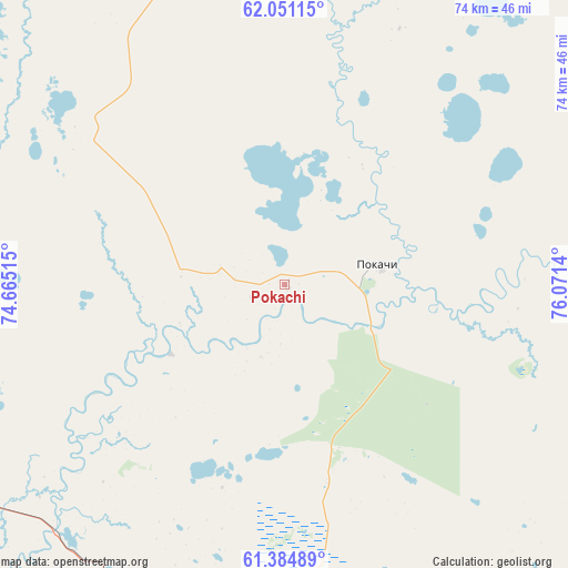
Pokachi GPS coordinates[2]
61° 43' 11.352" North, 75° 22' 5.772" East
| Map corner | latitude | longitude |
|---|---|---|
| Upper-left | 62.05115°, | 74.66515° |
| Center: | 61.71982°, | 75.36827° |
| Lower-right: | 61.38489°, | 76.0714° |
| Map W x H: | 74.1×74.1 km | = 46×46mi |
| max Lat: | 73.50819° ⇑5.7% North |
| Pokachi: | 61.71982° |
| min Lat: | ⇓94.3% South 41.28413° |
| min Long | Pokachi | max Long |
| -179.12198° | 75.36827° | 179.35046° |
| W 78.3%⇐ | ⇒21.7% E |
Elevation
Elevation of Pokachi is 54 m = 177 ft, and this is 148.6 m = 488 ft below average elevation for this country.
| Max E: |
2518 m = 8261 ft | 83.7% |
| Avg. | 202.6 m = 665 ft | |
| Pokachi | 54 m = 177 ft | |
Min E: |
-28 m = -92 ft | 16.3% |
See also: Russia elevation on elevation.city.
Geographical zone
Pokachi is located in North temperate zone (between Tropic of Cancer and the Arctic Circle). Distance of this North polar circle is 538.6 km =334.7 mi to North.| Distance of | km | miles | from Pokachi |
|---|---|---|---|
| North Pole | 3144.5 | 1953.9 | to North |
| Arctic Circle | 538.6 | 334.7 | to North |
| Tropic Cancer | 4256.7 | 2645 | to South |
| Equator | 6862.6 | 4264.2 | to South |


Nearby cities:
15 places around Pokachi: (largest is in red/bold)
• Barsovo
132.2 km =82.1 mi,  242°
242°
• Fedorovskiy
88.2 km =54.8 mi,  261°
261°
• Izluchinsk
116.9 km =72.6 mi,  134°
134°
• Kogalym
76.4 km =47.5 mi,  322°
322°
• Langepas
52.4 km =32.6 mi,  189°
189°
• Lokosovo
71.5 km =44.4 mi,  204°
204°
• Megion
86.4 km =53.7 mi,  152°
152°
• Nizhnevartovsk
107.8 km =67 mi,  144°
144°
• Novoagansk
72.4 km =45 mi,  69°
69°
• Poykovskiy
120.8 km =75.1 mi, 243°
• Raduzhny
118 km =73.3 mi, 69°
• Russkinskiye
104.3 km =64.8 mi,  297°
297°
• Singapay
157 km =97.6 mi,  246°
246°
• Solnechniy
125.9 km =78.2 mi, 247°
• Surgut
116 km =72.1 mi, 243°
Sources, notices
• [Note1] Compared only with cities in Russia existing in our database
• [Src1] Map data: © OpenStreetMap contributors (CC-BY-SA)
• [Src2] Other city data from geonames.org with taken over terms of usage.
• [Src3] Geographical zone / Annual Mean Temperature by Robert A. Rohde @ Wikipedia
