Lyantor geodata
Lyantor (Khanty-Mansia) is a populated place; located in Russia in Asia/Yekaterinburg (GMT+5) time zone. With population of 38,200 people, there are 546 cities with bigger population in this country. Compared to other cities in Russia, 94.1% of cities are located further ↓South; 77.3% of cities are located further ←West and 83.1% of cities have higher elevation than Lyantor. Note1


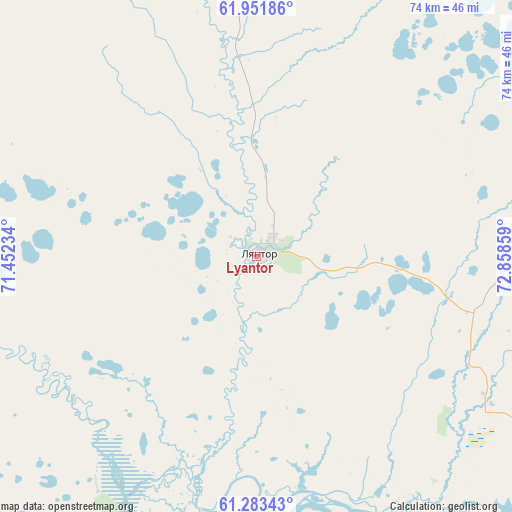
Lyantor GPS coordinates[2]
61° 37' 10.02" North, 72° 9' 19.656" East
| Map corner | latitude | longitude |
|---|---|---|
| Upper-left | 61.95186°, | 71.45234° |
| Center: | 61.61945°, | 72.15546° |
| Lower-right: | 61.28343°, | 72.85859° |
| Map W x H: | 74.3×74.3 km | = 46.2×46.2mi |
| max Lat: | 73.50819° ⇑5.9% North |
| Lyantor: | 61.61945° |
| min Lat: | ⇓94.1% South 41.28413° |
| min Long | Lyantor | max Long |
| -179.12198° | 72.15546° | 179.35046° |
| W 77.3%⇐ | ⇒22.7% E |
Elevation
Elevation of Lyantor is 57 m = 187 ft, and this is 145.6 m = 478 ft below average elevation for this country.
| Max E: |
2518 m = 8261 ft | 83.1% |
| Avg. | 202.6 m = 665 ft | |
| Lyantor | 57 m = 187 ft | |
Min E: |
-28 m = -92 ft | 16.9% |
See also: Russia elevation on elevation.city.
Geographical zone
Lyantor is located in North temperate zone (between Tropic of Cancer and the Arctic Circle). Distance of this North polar circle is 549.7 km =341.6 mi to North.| Distance of | km | miles | from Lyantor |
|---|---|---|---|
| North Pole | 3155.6 | 1960.8 | to North |
| Arctic Circle | 549.7 | 341.6 | to North |
| Tropic Cancer | 4245.5 | 2638 | to South |
| Equator | 6851.4 | 4257.3 | to South |


Nearby cities:
15 places around Lyantor: (largest is in red/bold)
• Barsovo
73.7 km =45.8 mi,  133°
133°
• Fedorovskiy
82.4 km =51.2 mi,  91°
91°
• Kogalym
141.1 km =87.7 mi,  59°
59°
• Langepas
167.5 km =104.1 mi,  104°
104°
• Lokosovo
151.7 km =94.3 mi,  110°
110°
• Nefteyugansk
62.5 km =38.8 mi,  157°
157°
• Nizhnesortymskiy
93.5 km =58.1 mi,  347°
347°
• Pokachi
169.9 km =105.6 mi, 86°
• Poykovskiy
75.9 km =47.2 mi,  124°
124°
• Pyt-Yakh
103.8 km =64.5 mi, 158°
• Russkinskiye
96.3 km =59.8 mi,  51°
51°
• Salym
177 km =110 mi,  191°
191°
• Singapay
58.3 km =36.2 mi,  152°
152°
• Solnechniy
66.3 km =41.2 mi, 124°
• Surgut
78.6 km =48.8 mi, 121°
Sources, notices
• [Note1] Compared only with cities in Russia existing in our database
• [Src1] Map data: © OpenStreetMap contributors (CC-BY-SA)
• [Src2] Other city data from geonames.org with taken over terms of usage.
• [Src3] Geographical zone / Annual Mean Temperature by Robert A. Rohde @ Wikipedia
