Megion geodata
Megion (Khanty-Mansia) is a populated place; located in Russia in Asia/Yekaterinburg (GMT+5) time zone. With population of 48,691 people, there are 436 cities with bigger population in this country. Compared to other cities in Russia, 92.9% of cities are located further ↓South; 78.4% of cities are located further ←West and 85.1% of cities have higher elevation than Megion. Note1


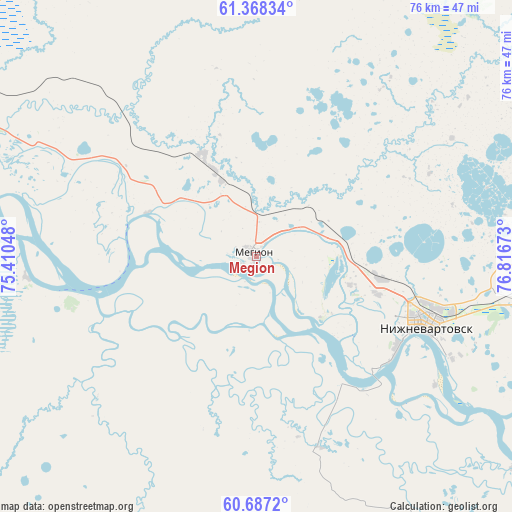
Megion GPS coordinates[2]
61° 1' 46.56" North, 76° 6' 48.96" East
| Map corner | latitude | longitude |
|---|---|---|
| Upper-left | 61.36834°, | 75.41048° |
| Center: | 61.0296°, | 76.1136° |
| Lower-right: | 60.6872°, | 76.81673° |
| Map W x H: | 75.7×75.7 km | = 47×47mi |
| max Lat: | 73.50819° ⇑7.1% North |
| Megion: | 61.0296° |
| min Lat: | ⇓92.9% South 41.28413° |
| min Long | Megion | max Long |
| -179.12198° | 76.1136° | 179.35046° |
| W 78.4%⇐ | ⇒21.6% E |
Elevation
Elevation of Megion is 47 m = 154 ft, and this is 155.6 m = 510 ft below average elevation for this country.
| Max E: |
2518 m = 8261 ft | 85.1% |
| Avg. | 202.6 m = 665 ft | |
| Megion | 47 m = 154 ft | |
Min E: |
-28 m = -92 ft | 14.9% |
See also: Megion elevation on elevation.city.
Geographical zone
Megion is located in North temperate zone (between Tropic of Cancer and the Arctic Circle). Distance of this North polar circle is 615.3 km =382.3 mi to North.| Distance of | km | miles | from Megion |
|---|---|---|---|
| North Pole | 3221.2 | 2001.6 | to North |
| Arctic Circle | 615.3 | 382.3 | to North |
| Tropic Cancer | 4179.9 | 2597.3 | to South |
| Equator | 6785.9 | 4216.6 | to South |


Nearby cities:
15 places around Megion: (largest is in red/bold)
• Barsovo
159.1 km =98.9 mi,  275°
275°
• Fedorovskiy
143.2 km =89 mi,  296°
296°
• Izluchinsk
44 km =27.3 mi,  97°
97°
• Kogalym
162.3 km =100.8 mi,  327°
327°
• Langepas
54.4 km =33.8 mi, 297°
• Lokosovo
70.7 km =43.9 mi, 279°
• Nizhnevartovsk
26 km =16.2 mi,  114°
114°
• Novoagansk
105.9 km =65.8 mi,  15°
15°
• Pokachi
86.4 km =53.7 mi, 332°
• Poykovskiy
150.9 km =93.8 mi, 278°
• Pyt-Yakh
178.8 km =111.1 mi,  259°
259°
• Raduzhny
138.8 km =86.2 mi,  31°
31°
• Solnechniy
159.7 km =99.2 mi, 280°
• Strezhevoy
86.4 km =53.7 mi, 112°
• Surgut
146.8 km =91.2 mi, 279°
Sources, notices
• [Note1] Compared only with cities in Russia existing in our database
• [Src1] Map data: © OpenStreetMap contributors (CC-BY-SA)
• [Src2] Other city data from geonames.org with taken over terms of usage.
• [Src3] Geographical zone / Annual Mean Temperature by Robert A. Rohde @ Wikipedia
