Nizhnevartovsk geodata
Nizhnevartovsk (Khanty-Mansia) is a populated place; located in Russia in Asia/Yekaterinburg (GMT+5) time zone. With population of 244,937 people, there are 77 cities with bigger population in this country. Compared to other cities in Russia, 92.7% of cities are located further ↓South; 78.4% of cities are located further ←West and 84.4% of cities have higher elevation than Nizhnevartovsk. Note1


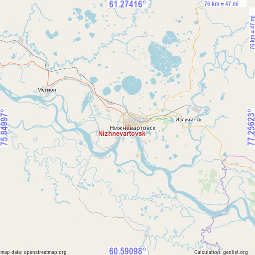
Nizhnevartovsk GPS coordinates[2]
60° 56' 3.84" North, 76° 33' 11.16" East
| Map corner | latitude | longitude |
|---|---|---|
| Upper-left | 61.27416°, | 75.84997° |
| Center: | 60.9344°, | 76.5531° |
| Lower-right: | 60.59098°, | 77.25623° |
| Map W x H: | 76×76 km | = 47.2×47.2mi |
| max Lat: | 73.50819° ⇑7.3% North |
| Nizhnevartovsk: | 60.9344° |
| min Lat: | ⇓92.7% South 41.28413° |
| min Long | Nizhnevartovsk | max Long |
| -179.12198° | 76.5531° | 179.35046° |
| W 78.4%⇐ | ⇒21.6% E |
Elevation
Elevation of Nizhnevartovsk is 50 m = 164 ft, and this is 152.6 m = 501 ft below average elevation for this country.
| Max E: |
2518 m = 8261 ft | 84.4% |
| Avg. | 202.6 m = 665 ft | |
| Nizhnevartovsk | 50 m = 164 ft | |
Min E: |
-28 m = -92 ft | 15.6% |
See also: Nizhnevartovsk elevation on elevation.city.
Geographical zone
Nizhnevartovsk is located in North temperate zone (between Tropic of Cancer and the Arctic Circle). Distance of this North polar circle is 625.9 km =388.9 mi to North.| Distance of | km | miles | from Nizhnevartovsk |
|---|---|---|---|
| North Pole | 3231.8 | 2008.1 | to North |
| Arctic Circle | 625.9 | 388.9 | to North |
| Tropic Cancer | 4169.4 | 2590.7 | to South |
| Equator | 6775.3 | 4210 | to South |


Nearby cities:
15 places around Nizhnevartovsk: (largest is in red/bold)
• Barsovo
184.1 km =114.4 mi,  278°
278°
• Fedorovskiy
169.1 km =105.1 mi,  296°
296°
• Izluchinsk
20.6 km =12.8 mi,  75°
75°
• Kogalym
184.2 km =114.5 mi,  323°
323°
• Langepas
80.4 km =50 mi, 296°
• Lokosovo
96.1 km =59.7 mi, 283°
• Megion
26 km =16.2 mi,  294°
294°
• Novoagansk
112.5 km =69.9 mi,  2°
2°
• Pokachi
107.8 km =67 mi, 324°
• Poykovskiy
176.2 km =109.5 mi, 280°
• Pyt-Yakh
201.2 km =125 mi,  264°
264°
• Raduzhny
138.1 km =85.8 mi,  20°
20°
• Solnechniy
185.1 km =115 mi, 281°
• Strezhevoy
60.4 km =37.5 mi,  111°
111°
• Surgut
172.2 km =107 mi, 281°
In other languages:
- In Spanish: Nizhnevártovsk
- In France: Nijnevartovsk
- In German: Nischnewartowsk
- In Italian: Nižnevartovsk
- In Russian: Нижневартовск
- In Chinese: 下瓦爾托夫斯克
Sources, notices
• [Note1] Compared only with cities in Russia existing in our database
• [Src1] Map data: © OpenStreetMap contributors (CC-BY-SA)
• [Src2] Other city data from geonames.org with taken over terms of usage.
• [Src3] Geographical zone / Annual Mean Temperature by Robert A. Rohde @ Wikipedia
