Tanais geodata
Tanais (Rostov) is a populated place; located in Russia in Europe/Moscow (GMT+3) time zone. With population of 1,942 people, there are 4198 cities with bigger population in this country. Compared to other cities in Russia, 81.8% of cities are located further ↑North; 70.8% of cities are located further →East and 91.6% of cities have higher elevation than Tanais. Note1


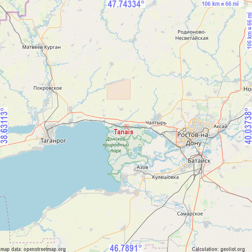
Tanais GPS coordinates[2]
47° 16' 6.132" North, 39° 20' 3.3" East
| Map corner | latitude | longitude |
|---|---|---|
| Upper-left | 47.74334°, | 38.63113° |
| Center: | 47.26837°, | 39.33425° |
| Lower-right: | 46.7891°, | 40.03738° |
| Map W x H: | 106.1×106.1 km | = 65.9×65.9mi |
| max Lat: | 73.50819° ⇑81.8% North |
| Tanais: | 47.26837° |
| min Lat: | ⇓18.2% South 41.28413° |
| min Long | Tanais | max Long |
| -179.12198° | 39.33425° | 179.35046° |
| W 29.2%⇐ | ⇒70.8% E |
Elevation
Elevation of Tanais is 23 m = 75 ft, and this is 179.6 m = 589 ft below average elevation for this country.
| Max E: |
2518 m = 8261 ft | 91.6% |
| Avg. | 202.6 m = 665 ft | |
| Tanais | 23 m = 75 ft | |
Min E: |
-28 m = -92 ft | 8.4% |
See also: Russia elevation on elevation.city.
Geographical zone
Tanais is located in North temperate zone (between Tropic of Cancer and the Arctic Circle). Distance of this North polar circle is 2145.4 km =1333.1 mi to North.| Distance of | km | miles | from Tanais |
|---|---|---|---|
| North Pole | 4751.3 | 2952.3 | to North |
| Arctic Circle | 2145.4 | 1333.1 | to North |
| Tropic Cancer | 2649.8 | 1646.5 | to South |
| Equator | 5255.8 | 3265.8 | to South |


Nearby cities:
15 places around Tanais: (largest is in red/bold)
• Azov
18.9 km =11.7 mi,  160°
160°
• Chaltyr
11.3 km =7 mi,  80°
80°
• Imeni Chkalova
31.3 km =19.4 mi,  87°
87°
• Kalinin
13.5 km =8.4 mi,  100°
100°
• Krym
14.2 km =8.8 mi, 75°
• Kuleshovka
27.1 km =16.8 mi,  141°
141°
• Nedvigovka
1.1 km =0.7 mi, 87°
• Persianovka
29.7 km =18.5 mi,  12°
12°
• Peshkovo
28.1 km =17.5 mi,  171°
171°
• Primorka
20.5 km =12.7 mi,  274°
274°
• Rostov-na-Donu
29.6 km =18.4 mi, 97°
• Severnyy
28.6 km =17.8 mi, 85°
• Sinyavskoye
4.3 km =2.7 mi,  282°
282°
• Taganrog
33.2 km =20.6 mi,  263°
263°
• Verkhnetemernitzkiy
30.7 km =19.1 mi, 81°
Sources, notices
• [Note1] Compared only with cities in Russia existing in our database
• [Src1] Map data: © OpenStreetMap contributors (CC-BY-SA)
• [Src2] Other city data from geonames.org with taken over terms of usage.
• [Src3] Geographical zone / Annual Mean Temperature by Robert A. Rohde @ Wikipedia
