Primorka geodata
Primorka (Rostov) is a populated place; located in Russia in Europe/Moscow (GMT+3) time zone. With population of 3,780 people, there are 3227 cities with bigger population in this country. Compared to other cities in Russia, 81.7% of cities are located further ↑North; 71.9% of cities are located further →East and 91.1% of cities have higher elevation than Primorka. Note1


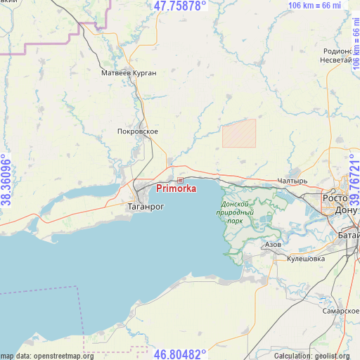
Primorka GPS coordinates[2]
47° 17' 2.22" North, 39° 3' 50.688" East
| Map corner | latitude | longitude |
|---|---|---|
| Upper-left | 47.75878°, | 38.36096° |
| Center: | 47.28395°, | 39.06408° |
| Lower-right: | 46.80482°, | 39.76721° |
| Map W x H: | 106.1×106.1 km | = 65.9×65.9mi |
| max Lat: | 73.50819° ⇑81.7% North |
| Primorka: | 47.28395° |
| min Lat: | ⇓18.3% South 41.28413° |
| min Long | Primorka | max Long |
| -179.12198° | 39.06408° | 179.35046° |
| W 28.1%⇐ | ⇒71.9% E |
Elevation
Elevation of Primorka is 24 m = 79 ft, and this is 178.6 m = 586 ft below average elevation for this country.
| Max E: |
2518 m = 8261 ft | 91.1% |
| Avg. | 202.6 m = 665 ft | |
| Primorka | 24 m = 79 ft | |
Min E: |
-28 m = -92 ft | 8.9% |
See also: Russia elevation on elevation.city.
Geographical zone
Primorka is located in North temperate zone (between Tropic of Cancer and the Arctic Circle). Distance of this North polar circle is 2143.7 km =1332 mi to North.| Distance of | km | miles | from Primorka |
|---|---|---|---|
| North Pole | 4749.6 | 2951.3 | to North |
| Arctic Circle | 2143.7 | 1332 | to North |
| Tropic Cancer | 2651.6 | 1647.6 | to South |
| Equator | 5257.5 | 3266.9 | to South |


Nearby cities:
15 places around Primorka: (largest is in red/bold)
• Azov
33.1 km =20.6 mi,  126°
126°
• Chaltyr
31.5 km =19.6 mi,  89°
89°
• Kalinin
34 km =21.1 mi,  96°
96°
• Krym
34.2 km =21.3 mi, 86°
• Kuleshovka
43.8 km =27.2 mi,  121°
121°
• Matveyev Kurgan
34.5 km =21.4 mi,  334°
334°
• Nedvigovka
21.5 km =13.4 mi, 94°
• Novobessergenovka
19.8 km =12.3 mi,  236°
236°
• Persianovka
38.2 km =23.7 mi,  44°
44°
• Peshkovo
38.4 km =23.9 mi,  140°
140°
• Pokrovskoye
19.3 km =12 mi,  319°
319°
• Severnyy
48.9 km =30.4 mi, 89°
• Sinyavskoye
16.2 km =10.1 mi, 92°
• Taganrog
13.7 km =8.5 mi,  247°
247°
• Tanais
20.5 km =12.7 mi, 94°
Sources, notices
• [Note1] Compared only with cities in Russia existing in our database
• [Src1] Map data: © OpenStreetMap contributors (CC-BY-SA)
• [Src2] Other city data from geonames.org with taken over terms of usage.
• [Src3] Geographical zone / Annual Mean Temperature by Robert A. Rohde @ Wikipedia
