Azov geodata
Azov (Rostov) is a seat of a second-order administrative division; located in Russia in Europe/Moscow (GMT+3) time zone. With population of 82,133 people, there are 255 cities with bigger population in this country. Compared to other cities in Russia, 82.1% of cities are located further ↑North; 70.4% of cities are located further →East and 87.2% of cities have higher elevation than Azov. Note1


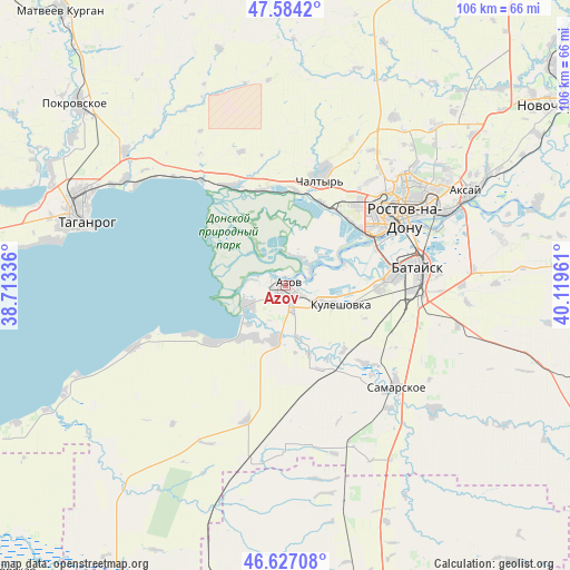
Azov GPS coordinates[2]
47° 6' 28.044" North, 39° 24' 59.328" East
| Map corner | latitude | longitude |
|---|---|---|
| Upper-left | 47.5842°, | 38.71336° |
| Center: | 47.10779°, | 39.41648° |
| Lower-right: | 46.62708°, | 40.11961° |
| Map W x H: | 106.4×106.4 km | = 66.1×66.1mi |
| max Lat: | 73.50819° ⇑82.1% North |
| Azov: | 47.10779° |
| min Lat: | ⇓17.9% South 41.28413° |
| min Long | Azov | max Long |
| -179.12198° | 39.41648° | 179.35046° |
| W 29.6%⇐ | ⇒70.4% E |
Elevation
Elevation of Azov is 39 m = 128 ft, and this is 163.6 m = 537 ft below average elevation for this country.
| Max E: |
2518 m = 8261 ft | 87.2% |
| Avg. | 202.6 m = 665 ft | |
| Azov | 39 m = 128 ft | |
Min E: |
-28 m = -92 ft | 12.8% |
See also: Azov elevation on elevation.city.
Geographical zone
Azov is located in North temperate zone (between Tropic of Cancer and the Arctic Circle). Distance of this North polar circle is 2163.3 km =1344.2 mi to North.| Distance of | km | miles | from Azov |
|---|---|---|---|
| North Pole | 4769.2 | 2963.4 | to North |
| Arctic Circle | 2163.3 | 1344.2 | to North |
| Tropic Cancer | 2632 | 1635.4 | to South |
| Equator | 5237.9 | 3254.7 | to South |


Nearby cities:
15 places around Azov: (largest is in red/bold)
• Bataysk
25.6 km =15.9 mi,  82°
82°
• Chaltyr
20.3 km =12.6 mi,  14°
14°
• Imeni Chkalova
31.7 km =19.7 mi,  52°
52°
• Kalinin
17 km =10.6 mi,  24°
24°
• Krym
22.7 km =14.1 mi, 19°
• Kuleshovka
11.2 km =7 mi,  107°
107°
• Nedvigovka
18.6 km =11.6 mi,  344°
344°
• Peshkovo
10.1 km =6.3 mi,  192°
192°
• Primorka
33.1 km =20.6 mi,  306°
306°
• Rostov-na-Donu
27 km =16.8 mi,  59°
59°
• Samarskoye
28 km =17.4 mi,  132°
132°
• Severnyy
30.1 km =18.7 mi, 47°
• Sinyavskoye
21.5 km =13.4 mi,  331°
331°
• Tanais
18.9 km =11.7 mi, 340°
• Verkhnetemernitzkiy
33.1 km =20.6 mi, 46°
Sources, notices
• [Note1] Compared only with cities in Russia existing in our database
• [Src1] Map data: © OpenStreetMap contributors (CC-BY-SA)
• [Src2] Other city data from geonames.org with taken over terms of usage.
• [Src3] Geographical zone / Annual Mean Temperature by Robert A. Rohde @ Wikipedia
