Rostov-na-Donu geodata
Rostov-na-Donu (Rostov) is a seat of a first-order administrative division; located in Russia in Europe/Moscow (GMT+3) time zone. With population of 1,074,482 people, there are 8 cities with bigger population in this country. Compared to other cities in Russia, 81.9% of cities are located further ↑North; 69% of cities are located further →East and 79% of cities have higher elevation than Rostov-na-Donu. Note1


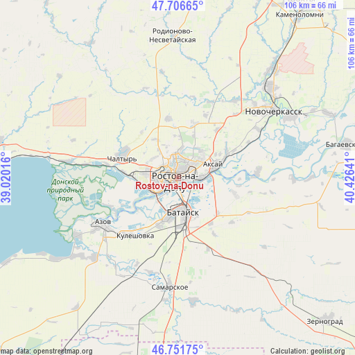
Rostov-na-Donu GPS coordinates[2]
47° 13' 52.86" North, 39° 43' 23.808" East
| Map corner | latitude | longitude |
|---|---|---|
| Upper-left | 47.70665°, | 39.02016° |
| Center: | 47.23135°, | 39.72328° |
| Lower-right: | 46.75175°, | 40.42641° |
| Map W x H: | 106.2×106.2 km | = 66×66mi |
| max Lat: | 73.50819° ⇑81.9% North |
| Rostov-na-Donu: | 47.23135° |
| min Lat: | ⇓18.1% South 41.28413° |
| min Long | Rostov-na-Donu | max Long |
| -179.12198° | 39.72328° | 179.35046° |
| W 31%⇐ | ⇒69% E |
Elevation
Elevation of Rostov-na-Donu is 74 m = 243 ft, and this is 128.6 m = 422 ft below average elevation for this country.
| Max E: |
2518 m = 8261 ft | 79% |
| Avg. | 202.6 m = 665 ft | |
| Rostov-na-Donu | 74 m = 243 ft | |
Min E: |
-28 m = -92 ft | 21% |
See also: Rostov-na-Donu elevation on elevation.city.
Geographical zone
Rostov-na-Donu is located in North temperate zone (between Tropic of Cancer and the Arctic Circle). Distance of this North polar circle is 2149.5 km =1335.6 mi to North.| Distance of | km | miles | from Rostov-na-Donu |
|---|---|---|---|
| North Pole | 4755.4 | 2954.9 | to North |
| Arctic Circle | 2149.5 | 1335.6 | to North |
| Tropic Cancer | 2645.7 | 1644 | to South |
| Equator | 5251.6 | 3263.2 | to South |


Nearby cities:
15 places around Rostov-na-Donu: (largest is in red/bold)
• Aksay
11.2 km =7 mi,  74°
74°
• Azov
27 km =16.8 mi,  239°
239°
• Bataysk
10.4 km =6.5 mi,  168°
168°
• Chaltyr
19.1 km =11.9 mi,  288°
288°
• Grushevskaya
28.9 km =18 mi,  36°
36°
• Imeni Chkalova
5.9 km =3.7 mi,  19°
19°
• Kalinin
16.1 km =10 mi,  276°
276°
• Krym
17.4 km =10.8 mi,  296°
296°
• Kuleshovka
21.1 km =13.1 mi,  216°
216°
• Nedvigovka
28.6 km =17.8 mi, 278°
• Ol’ginskaya
17.7 km =11 mi,  105°
105°
• Severnyy
6.5 km =4 mi,  352°
352°
• Starocherkasskaya
24.1 km =15 mi,  87°
87°
• Tanais
29.6 km =18.4 mi, 277°
• Verkhnetemernitzkiy
8.9 km =5.5 mi,  6°
6°
In other languages:
- In Spanish: Rostov del Don
- In France: Rostov-sur-le-Don
- In German: Rostow am Don
- In Italian: Rostov sul Don
- In Russian: Ростов-на-Дону
- In Chinese: 顿河畔罗斯托夫
Sources, notices
• [Note1] Compared only with cities in Russia existing in our database
• [Src1] Map data: © OpenStreetMap contributors (CC-BY-SA)
• [Src2] Other city data from geonames.org with taken over terms of usage.
• [Src3] Geographical zone / Annual Mean Temperature by Robert A. Rohde @ Wikipedia
