Chaltyr geodata
Chaltyr (Rostov) is a seat of a second-order administrative division; located in Russia in Europe/Moscow (GMT+3) time zone. With population of 14,689 people, there are 1107 cities with bigger population in this country. Compared to other cities in Russia, 81.7% of cities are located further ↑North; 70.1% of cities are located further →East and 83.4% of cities have higher elevation than Chaltyr. Note1


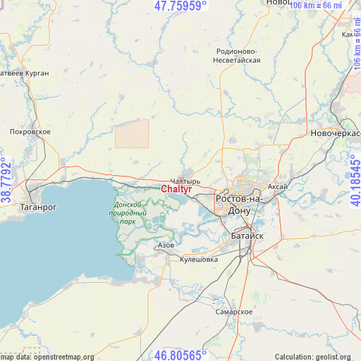
Chaltyr GPS coordinates[2]
47° 17' 5.172" North, 39° 28' 56.352" East
| Map corner | latitude | longitude |
|---|---|---|
| Upper-left | 47.75959°, | 38.7792° |
| Center: | 47.28477°, | 39.48232° |
| Lower-right: | 46.80565°, | 40.18545° |
| Map W x H: | 106.1×106.1 km | = 65.9×65.9mi |
| max Lat: | 73.50819° ⇑81.7% North |
| Chaltyr: | 47.28477° |
| min Lat: | ⇓18.3% South 41.28413° |
| min Long | Chaltyr | max Long |
| -179.12198° | 39.48232° | 179.35046° |
| W 29.9%⇐ | ⇒70.1% E |
Elevation
Elevation of Chaltyr is 56 m = 184 ft, and this is 146.6 m = 481 ft below average elevation for this country.
| Max E: |
2518 m = 8261 ft | 83.4% |
| Avg. | 202.6 m = 665 ft | |
| Chaltyr | 56 m = 184 ft | |
Min E: |
-28 m = -92 ft | 16.6% |
See also: Russia elevation on elevation.city.
Geographical zone
Chaltyr is located in North temperate zone (between Tropic of Cancer and the Arctic Circle). Distance of this North polar circle is 2143.6 km =1332 mi to North.| Distance of | km | miles | from Chaltyr |
|---|---|---|---|
| North Pole | 4749.5 | 2951.2 | to North |
| Arctic Circle | 2143.6 | 1332 | to North |
| Tropic Cancer | 2651.7 | 1647.7 | to South |
| Equator | 5257.6 | 3266.9 | to South |


Nearby cities:
15 places around Chaltyr: (largest is in red/bold)
• Aksay
29.2 km =18.1 mi,  95°
95°
• Azov
20.3 km =12.6 mi,  194°
194°
• Bataysk
26 km =16.2 mi,  128°
128°
• Imeni Chkalova
20.1 km =12.5 mi,  91°
91°
• Kalinin
4.7 km =2.9 mi,  152°
152°
• Krym
3.1 km =1.9 mi,  56°
56°
• Kuleshovka
23.7 km =14.7 mi,  166°
166°
• Nedvigovka
10.2 km =6.3 mi,  259°
259°
• Persianovka
27.7 km =17.2 mi,  349°
349°
• Peshkovo
30.4 km =18.9 mi, 193°
• Rostov-na-Donu
19.1 km =11.9 mi,  108°
108°
• Severnyy
17.4 km =10.8 mi, 88°
• Sinyavskoye
15.4 km =9.6 mi,  266°
266°
• Tanais
11.3 km =7 mi, 260°
• Verkhnetemernitzkiy
19.4 km =12.1 mi,  81°
81°
Sources, notices
• [Note1] Compared only with cities in Russia existing in our database
• [Src1] Map data: © OpenStreetMap contributors (CC-BY-SA)
• [Src2] Other city data from geonames.org with taken over terms of usage.
• [Src3] Geographical zone / Annual Mean Temperature by Robert A. Rohde @ Wikipedia
