Severnyy geodata
Severnyy (Rostov) is a seat of a fourth-order administrative division; located in Russia in Europe/Moscow (GMT+3) time zone. In our database, there are 4966 cities with bigger population. Compared to other cities in Russia, 81.6% of cities are located further ↑North; 69% of cities are located further →East and 83.7% of cities have higher elevation than Severnyy. Note1


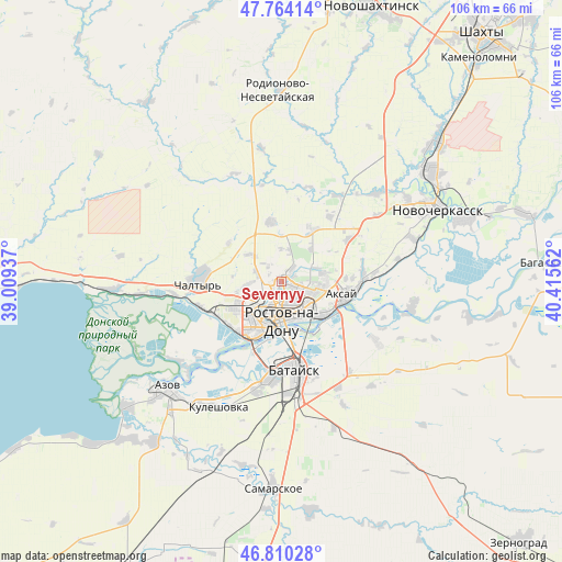
Severnyy GPS coordinates[2]
47° 17' 21.696" North, 39° 42' 44.964" East
| Map corner | latitude | longitude |
|---|---|---|
| Upper-left | 47.76414°, | 39.00937° |
| Center: | 47.28936°, | 39.71249° |
| Lower-right: | 46.81028°, | 40.41562° |
| Map W x H: | 106.1×106.1 km | = 65.9×65.9mi |
| max Lat: | 73.50819° ⇑81.6% North |
| Severnyy: | 47.28936° |
| min Lat: | ⇓18.4% South 41.28413° |
| min Long | Severnyy | max Long |
| -179.12198° | 39.71249° | 179.35046° |
| W 31%⇐ | ⇒69% E |
Elevation
Elevation of Severnyy is 54 m = 177 ft, and this is 148.6 m = 488 ft below average elevation for this country.
| Max E: |
2518 m = 8261 ft | 83.7% |
| Avg. | 202.6 m = 665 ft | |
| Severnyy | 54 m = 177 ft | |
Min E: |
-28 m = -92 ft | 16.3% |
See also: Russia elevation on elevation.city.
Geographical zone
Severnyy is located in North temperate zone (between Tropic of Cancer and the Arctic Circle). Distance of this North polar circle is 2143.1 km =1331.7 mi to North.| Distance of | km | miles | from Severnyy |
|---|---|---|---|
| North Pole | 4749 | 2950.9 | to North |
| Arctic Circle | 2143.1 | 1331.7 | to North |
| Tropic Cancer | 2652.2 | 1648 | to South |
| Equator | 5258.1 | 3267.2 | to South |


Nearby cities:
15 places around Severnyy: (largest is in red/bold)
• Aksay
12.1 km =7.5 mi,  106°
106°
• Azov
30.1 km =18.7 mi,  227°
227°
• Bataysk
16.9 km =10.5 mi,  169°
169°
• Chaltyr
17.4 km =10.8 mi,  268°
268°
• Grushevskaya
24.6 km =15.3 mi,  46°
46°
• Imeni Chkalova
2.9 km =1.8 mi, 107°
• Kalinin
15.9 km =9.9 mi,  252°
252°
• Krym
14.8 km =9.2 mi, 274°
• Kuleshovka
26.2 km =16.3 mi,  206°
206°
• Nedvigovka
27.5 km =17.1 mi, 265°
• Ol’ginskaya
21.1 km =13.1 mi,  122°
122°
• Rostov-na-Donu
6.5 km =4 mi, 172°
• Starocherkasskaya
25.4 km =15.8 mi,  102°
102°
• Tanais
28.6 km =17.8 mi, 265°
• Verkhnetemernitzkiy
3 km =1.9 mi,  37°
37°
Sources, notices
• [Note1] Compared only with cities in Russia existing in our database
• [Src1] Map data: © OpenStreetMap contributors (CC-BY-SA)
• [Src2] Other city data from geonames.org with taken over terms of usage.
• [Src3] Geographical zone / Annual Mean Temperature by Robert A. Rohde @ Wikipedia
