Koashva geodata
Koashva (Murmansk) is a populated place; located in Russia in Europe/Moscow (GMT+3) time zone. With population of 882 people, there are 4713 cities with bigger population in this country. Compared to other cities in Russia, 98.9% of cities are located further ↓South; 90.4% of cities are located further →East and 82.1% of cities have lower elevation than Koashva. Note1


Koashva GPS coordinates[2]
67° 39' 20.988" North, 34° 4' 55.992" East
| Map corner | latitude | longitude |
|---|---|---|
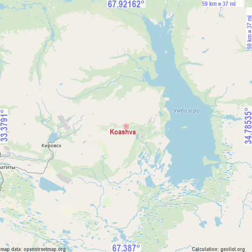
| Upper-left | 67.92162°, | 33.3791° |
| Center: | 67.65583°, | 34.08222° |
| Lower-right: | 67.387°, | 34.78535° |
| Map W x H: | 59.4×59.4 km | = 36.9×36.9mi |
| max Lat: | 73.50819° ⇑1.1% North |
| Koashva: | 67.65583° |
| min Lat: | ⇓98.9% South 41.28413° |
| min Long | Koashva | max Long |
| -179.12198° | 34.08222° | 179.35046° |
| W 9.6%⇐ | ⇒90.4% E |
Elevation
Elevation of Koashva is 275 m = 902 ft, and this is 72.4 m = 238 ft above average elevation for this country.
| Max E: |
2518 m = 8261 ft | 17.9% |
| Koashva | 275 m 902 ft | |
| Avg. | 202.6 m = 665 ft | |
Min E: |
-28 m = -92 ft | 82.1% |
See also: Russia elevation on elevation.city.
Geographical zone
Koashva is located in North Frigid zone (between North Pole and Arctic Circle). Distance of this North polar circle is 121.4 km =75.4 mi to South.| Distance of | km | miles | from Koashva |
|---|---|---|---|
| North Pole | 2484.4 | 1543.7 | to North |
| Arctic Circle | 121.4 | 75.4 | to South |
| Tropic Cancer | 4916.7 | 3055.1 | to South |
| Equator | 7522.6 | 4674.3 | to South |


Nearby cities:
15 places around Koashva: (largest is in red/bold)
• Afrikanda
60 km =37.3 mi,  246°
246°
• Apatity
30.5 km =19 mi, 250°
• Kandalaksha
90 km =55.9 mi,  232°
232°
• Kirovsk
17.9 km =11.1 mi,  255°
255°
• Lovozero
55.3 km =34.4 mi,  45°
45°
• Monchegorsk
59.8 km =37.2 mi,  301°
301°
• Olenegorsk
64.3 km =40 mi,  327°
327°
• Polyarnyye Zori
74.7 km =46.4 mi,  244°
244°
• Poyakonda
130 km =80.8 mi,  204°
204°
• Revda
37.2 km =23.1 mi,  32°
32°
• Shonguy
127.9 km =79.5 mi,  342°
342°
• Umba
108.3 km =67.3 mi,  174°
174°
• Vysokiy
60.1 km =37.3 mi, 332°
• Zasheyek
71 km =44.1 mi, 246°
• Zelenoborskiy
116.6 km =72.5 mi,  219°
219°
Sources, notices
• [Note1] Compared only with cities in Russia existing in our database
• [Src1] Map data: © OpenStreetMap contributors (CC-BY-SA)
• [Src2] Other city data from geonames.org with taken over terms of usage.
• [Src3] Geographical zone / Annual Mean Temperature by Robert A. Rohde @ Wikipedia
